Characterization of 500 of the largest Texas oil reservoirs permits grouping into plays of similar geology and common engineering and production attributes. Most of the major oil reservoirs of Texas are included in 48 plays, which account for 71 percent (32 billion barrels cumulative) of all historical production in Texas. Twenty-seven oil plays lie north and west of the Marathon-Ouachita structural front in Paleozoic reservoirs that are predominantly dolomite and that contained 73 percent of the original oil in place (OOIP) in Texas.
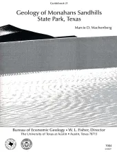
Sand dunes at Monahans Sandhills State Park display a variety of dune forms that develop under a unique trimodal wind regime. Large expanses of unvegetated sand form akle dunes having reversing slip faces. Smaller dune forms in the park include wind-shadow, coppice, transverse, barchan, and parabolic dunes. Blowout dunes also occur in the heavily vegetated cover sands of the Pecos Plain surface. Seasonal wind regimes can be divided into three groups: summer, winter, and spring winds. Persistent summer winds from the south-southeast build long transverse dunes.