This report summarizes results of the East Texas Waste Isolation (ETWI) program from January 1, 1978, to March 30, 1983. Having an extensive data base, the study comprised 33 different lines of research by 67 scientists and research assistants. The program included both basinwide and site-specific (mainly around Oakwood Dome) studies that used surface and subsurface data.
Permian strata in the Texas Panhandle exhibit a variety of deformation styles that are attributed to tectonic stresses as well as to collapse caused by evaporite dissolution. At Caprock Canyons State Park, deformation structures above salt dissolution zones include veins, faults, and folds. The geometry and distribution of the structures indicate that systematic regional joints older than the dissolution collapse have influenced salt dissolution.
Several microearthquake recording stations were operated as a network in the East Texas Basin beginning in June 1981. At least six certain and two probable earthquakes as well as hundreds of events of undetermined origin were recorded through August 1982. Three of the earthquakes were felt by people in East Texas, including one earthquake and an aftershock at Jacksonville and one earthquake near Center. The Jacksonville earthquake and the Center earthquake were recorded at enough stations to be located instrumentally.
Correct interpretation of the effect of basin infilling on salt mobilization is critical to understanding salt dome growth and stability. The size of salt structures in the East Texas Basin is determined by the original thickness of the underlying Louann Salt (Middle Jurassic). That is, salt structures distinctly increase in size toward the interior of the basin. Initial movement of salt apparently occurred in the marginal areas of the basin during Smackover (Late Jurassic) deposition.
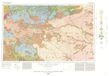
Oversize color geologic map that depicts the surface geology of Dallam County and parts of Sherman, Moore, and Hartley Counties, Texas. The 6-page booklet indicates geologic formations, abbreviations, and ages.