Bureau of Economic Geology Publications
| Title | Publication Year Sort ascending | Abstract | Author | Publisher | |
|---|---|---|---|---|---|
|
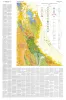
Geology of Van Horn Mountains, Texas | 1959 | About 10 miles south of Van Horn, Texas, the Van Horn Mountains rise abruptly above an intermontane plain and extend southward to the Sierra Vieja. The area lies primarily in the southwestern part of Culberson County but extends into Hudspeth and Jeff Davis counties. |
Twiss, P.C. | Bureau of Economic Geology |
|
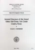
Internal structure of the Grand Saline Salt Dome, Van Zandt County, Texas | 1959 | Since 1947, the Morton Salt Company's Kleer mine in the Grand Saline salt dome has more than doubled in size. |
Muehlberger, W.R. | Bureau of Economic Geology |
|
Correlation of the Ogallala Formation (Neogene) in Western Texas with Type Localities in Nebraska | 1959 | The Ogallala formation extends from the north side of the Pecos Valley northward across western Texas, Oklahoma, Kansas, and Nebraska into southern South Dakota. |
Frye, J.C., Leonard, A.B. | Bureau of Economic Geology |
|
Vermiculite in central Texas | 1959 | Vermiculite deposits in the Central Mineral region of Texas, chiefly in Precambrian metamorphic rocks, are situated in Llano County and adjacent parts of Mason, Gillespie, and Burnet counties with minor occurrences in Blanco and San Saba counties. |
Clabaugh, S.E., Barnes, V.E. | Bureau of Economic Geology |
|
A Review of Pennsylvanian Clay Mineral Industries, North-Central Texas | 1959 | Brown, L.F., Jr. | Bureau of Economic Geology | |
|
The Mineral Industry of Texas in 1958 | 1959 | Netzeband, F.F., Lonsdale, J.T. | Bureau of Economic Geology | |
|
Comanchean Stratigraphy of Kent Quadrangle, Trans-Pecos Texas | 1958 | At the northern end of the Coahuila platform, the thinned Comanchean sequence consists of the newly named Sixshooter group of carbonate formations underlain by the newly named Yearwood formation. |
Brand, J.P., DeFord, R.K. | Bureau of Economic Geology |
|
Texas Miners Boost Talc Output | 1958 | Texas' Hudspeth County talc mining, begun in 1952 when Southwestern Talc Corp. carried out pioneer exploratory operations, has expanded during the last five years and can today claim six active operations. These Include (1) Southwestern Talc Corp., Llano, Texas, (2) West Texas Talc Corp. |
Flawn, P.T. | Bureau of Economic Geology |
|
Geology of the Pinto Canyon Area, Presidio County, Texas | 1958 | Amsbury, D.L. | Bureau of Economic Geology | |
|
Tertiary formations of Rim Rock country, Presidio County, Trans-Pecos Texas | 1958 | The rim rock of the Vieja Rim, the quartz pantellerite of Lord, is named the Bracks Rhyolite. |
DeFord, R.K. | Bureau of Economic Geology |