Bureau of Economic Geology Publications
| Title | Publication Year Sort ascending | Abstract | Author | Publisher | |
|---|---|---|---|---|---|
|
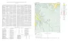
Geologic map of the Fall Prong Quadrangle, Kimble, Gillespie and Mason Counties, Texas | 1956 | Fall Prong quadrangle is in the marginal portion of the Edwards Plateau near the southeastern corner of the Llano region. Almost three-quarters of the quadrangle is within the Edwards Plateau, and the rest consists of valleys of the Llano basin cutting back into the plateau. |
Barnes, V.E. | Bureau of Economic Geology |
|
Enchanted rock batholith, Llano and Gillespie Counties, Texas | 1956 | Hutchinson, R.M. | Bureau of Economic Geology | |
|
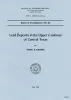
Lead deposits in the Upper Cambrian of central Texas | 1956 | The lead and zinc deposits in the Upper Cambrian rocks of central Texas are reviewed in the light of new detailed information. Included are analytical data for all deposits, detailed stratigraphic sections of the Cambrian rocks, and maps at a scale of 4 inches to the mile. |
Barnes, V.E. | Bureau of Economic Geology |
|
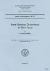
Some uranium occurrences in West Texas | 1956 | Uranium minerals have been found at several localities in west Texas. In the King Mountain area in southwestern Upton County carnotite forms coatings along joint planes and in borings in marineCretaceous limestone. |
Eargle, D.H. | Bureau of Economic Geology |
|
Prospecting for Uranium in Texas | 1955 | Flawn, P.T., Anderson, G.H. | Bureau of Economic Geology | |
|
Mineral Resources of the Texas Coastal Plain (Preliminary Report) | 1955 | Perkins, J.M., Lonsdale, J.T. | Bureau of Economic Geology | |
| |
Cross section, Post-Ellenburger beds, Coke, Runnels, Coleman, and Brown Counties, Texas | 1955 | Morey, P.S. | Bureau of Economic Geology | |
|
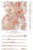
Cathedral Mountain quadrangle, Brewster County, Texas | 1955 | McAnulty, W.N. | Bureau of Economic Geology | |
|
Geology of Cathedral Mountain quadrangle, Brewster County, Texas | 1955 | Rocks exposed in the Cathedral Mountain quadrangle in the southeastern DavisMountains of Trans-Pecos Texas are assigned to the Word formation and to Capitan limestone in the Permian Guadalupe series; to the Maxon sandstone, Edwards limestone, Georgetown limestone, and Grayson (Del Rio) marl in th |
McAnulty, W.N. | Bureau of Economic Geology |
| |
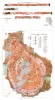
Map showing correlation of geologic, gravity, and magnetic observations, Blanco and Gillespie Counties, Texas | 1955 | Barnes, V.E., Romberg, Frederick, Anderson, W.A. | Bureau of Economic Geology |