Bureau of Economic Geology Publications
| Title | Publication Year Sort ascending | Abstract | Author | Publisher | |
|---|---|---|---|---|---|
|
Heavy minerals in the Wellborn Formation, Lee and Burleson Counties, Texas | 1965 | At five places along the outcrop of the Wellborn Formation in Lee and Burleson counties, Texas, anomalously high gamma radiation is associated with concentrations of heavy minerals. The most abundant heavy minerals are ilmenite, magnetite, and zircon. |
Shelby, C.A. | Bureau of Economic Geology |
|
The Mineral Industry of Texas in 1964 | 1965 | Netzeband, F.F., Pierce, H.F., Girard, R.M. | Bureau of Economic Geology | |
|
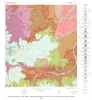
Geology of the Hye Quadrangle, Blanco, Gillespie, and Kendall Counties, Texas | 1965 | Hye quadrangle includes part of the southeastern Llano region and part of the eastern margin of the Edwards Plateau where most of the Plateau surface has been destroyed by erosion. |
Barnes, V.E. | Bureau of Economic Geology |
|
The Mineral Industry of Texas in 1965 | 1965 | Netzeband, F.F., Girard, R.M. | Bureau of Economic Geology | |
|
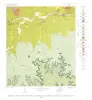
Geology of the Rocky Creek Quadrangle, Blanco and Gillespie Counties, Texas | 1965 | Barnes, V.E. | Bureau of Economic Geology | |
|
Geology of the Stonewall Quadrangle, Gillespie and Kendall Counties, Texas | 1965 | Stonewall quadrangle includes part of the southern margin of the Llano region and part of the eastern margin of the Edwards Plateau where most of the plateau suriace has been destroyed by erosion. |
Barnes, V.E. | Bureau of Economic Geology |
|
Oil and Water: Related Resource Problems of the Southwest. A Symposium | 1965 | This volume presents the texts of papers presented at a Symposium...sponsored by the Southwestern Federation of Geological Societies and The University of Texas in Austin, January 29, 1965. |
Bureau of Economic Geology | |
|
Bloating characteristics of East Texas clays | 1965 | Incidence of bloating among approximately 600 clay samples from East Texas, ranging in age from Gulfian (Late Cretaceous) to Recent, correlates principally with clay mineralogy-and pH--together an indication of bulk composition--and to a lesser extent with texture, loss on ignition, and content o |
Fisher, W.L., Garner, L.E. | Bureau of Economic Geology |
|
Texas Mineral Resources: Problems and Predictions | 1965 | When a reference is made to the mineral resources of Texas, most people think of oil and gas, and some few also of sulfur. And, of course, it is true that of the whopping $4.4 billion dollars’ worth of minerals produced in Texas in 1963, 92% was oil, gas, and natural gas liquids. |
Flawn, P.T. | Bureau of Economic Geology |
|
Texas Rocks and Minerals: An Amateur's Guide | 1964 | Texas has a great variety of rocks and minerals some are common and others are not. This book is designed to aquaint you with some of them and to tell you in a nontechnical way what they are like, some of the places where they are found, and how they are used. |
Girard, R.M. | Bureau of Economic Geology |