Bureau of Economic Geology Publications
| Title | Publication Year Sort ascending | Abstract | Author | Publisher | |
|---|---|---|---|---|---|
|
Relation of Ogallala Formation to the southern High Plains in Texas | 1964 | Studies along the southern and southeastern borders of the High Plains have demonstrated the presence of outliers of fossiliferous Ogallala Formation in Borden and Scurry counties and have documented the occurrence of Pliocene deposition as far southeast as Sterling County. |
Frye, J.C., Leonard, A.B. | Bureau of Economic Geology |
|
Stratigraphy of the Fredericksburg Division, south-central Texas | 1964 | Sediments of the Fredericksburg Division in south-central Texas were deposited on the slowly subsiding west flank of the Tyler basin. In this region there are three stratigraphically distinct areas. The southern area has a thick Edwards Limestone unit overlying a thin Walnut Formation. |
Moore, C.H. | Bureau of Economic Geology |
|
Potential low-grade iron ore and hydraulic-fracturing sand in Cambrian sandstones, northwestern Llano region, Texas | 1964 | The red upper unit of the Hickory Sandstone is a hematitic and goethitic sandstone containing a large reserve of potential low-grade iron ore. |
Barnes, V.E., Schofield, D.A. | Bureau of Economic Geology |

|
The Mineral Industry of Texas in 1963 | 1964 | Netzeband, F.F., Girard, R.M. | Bureau of Economic Geology | |
|
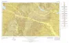
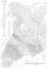
Geologic Atlas of Texas, Tyler sheet | 1964 | Geologic map that depicts the surface geology of Rains, Wood, Upshur, Marion, Harrison, Smith, and Gregg Counties and parts of Camp, Cass, Panola, Rusk, Cherokee, Anderson, Henderson, Van Zandt, Hunt, Morris, Franklin, and Hopkins Counties, Texas. |
Barnes, V.E., Shell Oil Co., Humble Oil and Refining Co., Mobil Oil Co., Pan American Petroleum Corp., Eaton, R.W., Wright, A.C., McCallum, H.D. | Bureau of Economic Geology |
|
Pleistocene geology of Red River basin in Texas | 1963 | The Red River rises in northeastern New Mexico and extends across northern Texas and east of the Panhandle serves as the northern border of that State. The late Cenozoic geology of the Red River basin has been studied intensively in northwestern Texas and in Louisiana. |
Frye, J.C., Leonard, A.B. | Bureau of Economic Geology |
|
Geologic map of Southeastern Llano Uplift, Llano, Burnet, Blanco, and Gillespie counties, Texas | 1963 | McGehee, R.V. | Bureau of Economic Geology | |
|
Lignites of the Texas Gulf coastal plain | 1963 | One of the basic mineral resources of Texas is abundant deposits of lignite in Eocene rocks of the Gulf Coastal Plain. |
Fisher, W.L. | Bureau of Economic Geology |
|
The Mineral Industry of Texas in 1962 | 1963 | Netzeband, F.F., Early, T.R., Girard, R.M. | Bureau of Economic Geology | |
|
Geology of the Johnson City Quadrangle, Blanco County, Texas | 1963 | Barnes, V.E. | Bureau of Economic Geology |