Bureau of Economic Geology Publications
| Title | Publication Year Sort ascending | Abstract | Author | Publisher | |
|---|---|---|---|---|---|
|
Correlation of Cambrian Rocks in Central Texas | 1963 | Barnes, V.E. | Bureau of Economic Geology | |
|
Hurricanes as Geological Agents: Case Studies of Hurricanes Carla, 1961, and Cindy, 1963 | 1963 | Tropical storms, which cross the Texas coastline with a frequency of 0.67 storms per year, play a major role in nearshore sedimentation on the south Texas coast. Greatest geological effects of these storms are produced by wind-driven waves and by storm surges. |
Hayes, M.O. | Bureau of Economic Geology |
|
The geologic story of Longhorn Cavern | 1963 | Bureau of Economic Geology | ||
|
Field excursion - geology of Llano region and Austin area | 1963 | Barnes, V.E., Bell, W.C., Clabaugh, S.E., Cloud, P.E., Jr., Young, Keith, McGehee, R.V. | Bureau of Economic Geology | |
|
Pleistocene geology of Red River basin in Texas | 1963 | The Red River rises in northeastern New Mexico and extends across northern Texas and east of the Panhandle serves as the northern border of that State. The late Cenozoic geology of the Red River basin has been studied intensively in northwestern Texas and in Louisiana. |
Frye, J.C., Leonard, A.B. | Bureau of Economic Geology |
|
Reconnaissance of Trace Elements in Texas Coal and Lignite | 1962 | Kohls, D.W. | Bureau of Economic Geology | |
|
The Mineral Industry of Texas in 1961 | 1962 | Netzeband, F.F., Early, T.R., Girard, R.M. | Bureau of Economic Geology | |
|
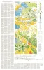
Geology of Eastern Half of Kent Quadrangle, Culberson, Reeves, and Jeff Davis Counties, Texas | 1962 | Study of Permian, Cretaceous, and Cenozoic rocks in the 30 Kent quad- rangle is important to an understanding of the geology of Trans-Pecos Texas. Most of the Cretaceoua rock units of central Texas lose their lithostratigraphic identity when traced into west Texas. |
Brand, J.P., DeFord, R.K. | Bureau of Economic Geology |
|
Mineral resources of south Texas: region served through the port of Corpus Christi | 1962 | This report is a compilation of all available data on mineral resources (exclusive of oil and gas) in 39 south Texas counties. Information from published and unpublished sources was checked and supplemented by field investigations. |
Maxwell, R.A. | Bureau of Economic Geology |
|
Pleistocene molluscan faunas and physiographic history of Pecos Valley in Texas | 1962 | Studies of physiographic relations and of fossil molluscan faunas made in the Pecos River valley region (Val Verde County to the Texas�New Mexico border) reveal extensive, well-pedimented surfaces southwest of the river extending from the Davis Mountains to near the present channel. |
Leonard, A.B., Frye, J.C. | Bureau of Economic Geology |