Bureau of Economic Geology Publications
| Title | Publication Year Sort ascending | Abstract | Author | Publisher | |
|---|---|---|---|---|---|
|
Stratigraphy and petrology of the Tascotal Mesa quadrangle, Texas | 1953 | The Tascotal Mesa quadrangle is in southeastern Presidio and southwestern Brewster counties, Trans Pecos Texas. Bandera Mesa and Tascotal Mesa are reached most easily from Marfa, 50 miles north, by the Marfa-Lajitas road which traverses the quadrangle from north to south. |
Erickson, R.L. | Bureau of Economic Geology |
|
Paleontology of the Rustler Formation, Culberson County, Texas | 1953 | The fossils described in this paper substantiate the Permian age of the Rustler formation. The Rustler fauna is largely molluscan and has a Whitehorse aspect. |
Walter, J.C. | Bureau of Economic Geology |
|
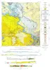
Tascotal Mesa Quadrangle, Brewster and Presidio Counties, Texas | 1953 | Erickson, R.L. | Bureau of Economic Geology | |
|
Cretaceous of Llano Estacado of Texas | 1953 | Rocks of Cretaceous age crop out along the western margins of the deeper playa basins and along the southern and southeastern margins of the Llano Estacado. |
Brand, J.P. | Bureau of Economic Geology |
|
Geologic map of Chinati Peak quadrangle, Presidio County, Texas | 1953 | Rix, C.C. | Bureau of Economic Geology | |
|
Geology of the Agua Fria quadrangle, Brewster County, Texas | 1953 | The 15-minute Agua Fria quadrangle in southwestern Brewster County, Texas, is arid, sparsely vegetated, and includes diverse topographic features that result chiefly from complex structure and variation in rock resistance to erosion. |
Moon, C.G. | Bureau of Economic Geology |
|
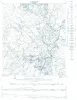
Geologic map of the Hilltop Quadrangle, Gillespie, Llano, and Mason Counties, Texas | 1952 | Barnes, V.E. | Bureau of Economic Geology | |
|
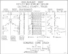
Edwards Core Study | 1952 | Feray, D.E., Jr. | Bureau of Economic Geology | |
|
The Hazel copper-silver mine, Culberson County, Texas | 1952 | The Hazel mine is one of the oldest mines in Texas and has been the largest copper-producing property in the State. |
Flawn, P.T. | Bureau of Economic Geology |
|
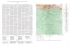
Geologic Map of the Crabapple Creek Quadrangle Gillespie and Llano Counties, Texas | 1952 | Barnes, V.E. | Bureau of Economic Geology |