Publications by Twiss, P.C.
| Title | Publication Year Sort ascending | Abstract | Author | Series | Publisher | |
|---|---|---|---|---|---|---|
|
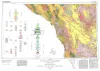
Geologic Atlas of Texas, Marfa sheet | 1979 | Geologic map that depicts surface geology of parts of Hudspeth, Culberson, Jeff Davis, and Presidio Counties, Texas. The 12-page explanatory booklet indicates geologic formations, abbreviations, and ages. |
Barnes, V.E., Twiss, P.C., Continental Oil Co., Cities Service Petroleum Co., Geophoto Services Inc., Norman, D.M., Sherrod, C.H., Pearson, B.T. | Geologic Atlas of Texas | Bureau of Economic Geology |
|
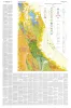
Geology of Van Horn Mountains, Texas | 1959 | About 10 miles south of Van Horn, Texas, the Van Horn Mountains rise abruptly above an intermontane plain and extend southward to the Sierra Vieja. The area lies primarily in the southwestern part of Culberson County but extends into Hudspeth and Jeff Davis counties. |
Twiss, P.C. | Geologic Quadrangle Map | Bureau of Economic Geology |