Publications by Muehlberger, W.R.
| Title | Publication Year Sort ascending | Abstract | Author | Series | Publisher | |
|---|---|---|---|---|---|---|
|
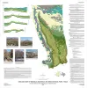
Geologic map of Mariscal Mountain, Big Bend National Park, Texas | 2010 | Dickerson, P.W., Muehlberger, W.R., Collins, E.W. | Miscellaneous Map | Bureau of Economic Geology | |
| |
Geologic map of the Glenn Spring quadrangle, Big Bend National Park, Texas | 2008 | Collins, E.W., Muehlberger, W.R., Dickerson, P.W. | Miscellaneous Map | Bureau of Economic Geology | |
|
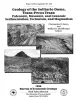
Geology of the Solitario dome, Trans-Pecos Texas: Paleozoic, Mesozoic, and Cenozoic sedimentation, tectonism, and magmatism | 1996 | The Solitario is a circular, 14- to 16-krn-diameter, mid-Tertiary laccolithic dome and caldera in southern Trans-Pecos Texas; it is among the world's largest laccoliths. |
Henry, C.D., Muehlberger, W.R., McCormick, C.L., Smith, C.I., Erdlac, R.J., Davis, L.L., Kunk, M.J. | Report of Investigations | Bureau of Economic Geology |
|
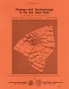
Geology and geohydrology of the east Texas basin -- a report on the progress of nuclear waste isolation feasibility studies (1980) | 1981 | The third year of research was highlighted by the integration of regional basinal studies with growth histories for specific domes, studies of cap-rock diagenesis and salt deformation, preliminary studies of ground-water flow and geochemistry around Oakwood Dome, and preliminary studies of micros |
Kreitler, C.W., Collins, E.W., Davidson, E.D., Dix, O.R., Donaldson, G.A., Dutton, S.P., Fogg, G.E., Giles, A.B. | Geological Circular | Bureau of Economic Geology |
|
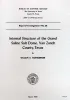
Internal structure of the Grand Saline Salt Dome, Van Zandt County, Texas | 1959 | Since 1947, the Morton Salt Company's Kleer mine in the Grand Saline salt dome has more than doubled in size. |
Muehlberger, W.R. | Report of Investigations | Bureau of Economic Geology |