Publication Details
Geolocation:
Get the Publication
$14.50
Abstract/Description:
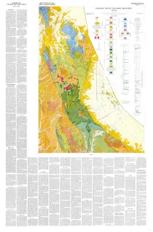
About 10 miles south of Van Horn, Texas, the Van Horn Mountains rise abruptly above an intermontane plain and extend southward to the Sierra Vieja. The area lies primarily in the southwestern part of Culberson County but extends into Hudspeth and Jeff Davis counties. The mountains owe their present topographic form to late Tertiary block-faulting. Structurally, they are a northward-trending horst which is flanked on the east and west by intermontane basins. The basin east of the mountains is herein named "lobo bolson": although structurally separate, it is topographically a southern extension of Salt Basin. An outcrop (30� 46.5� N., 105� 55.5' W.) of Tertiary volcanic rock separates two structural basins west of the mountains: the southern basin is herein named "Green River bolson." Topographically, the northern part of the northern basin is a southeastern extension of Eagle Flat. In addition to the major, generally north-south high-angle normal faults that define the horst, many normal faults of lesser magnitude cut the highland mass of the Van Horns; they are either nearly parallel to or at large angles to the strike of the horst. In the southern part of the area are three thrust faults of Laramide age. Older Comanchean strata on the west are thrust over younger Cretaceous strata on the east. These faults occurred before the outflow of lava in the Davis Mountains. The northern segment of the mountains, where Precambrian metasedimentary rocks are exposed, is within the southern boundary of the Van Horn uplift. Rocks of Permian, Cretaceous, and Tertiary age dip generally to the south at about 4 degrees. The area lies along the junction of the Chihuahua tectonic belt on the west and Diablo Platform on the east. The Tertiary volcanic rocks are part of the Davis Mountains lava field, which is the greatest exposure of volcanic rock in Texas. Stream flow of the region is intermittent. Salt Basin, collecting water from Eagle Flat and from the northern and eastern parts of the Van Horn Mountains, is a prominent basin of interior drainage. Water flows northward from Lobo Flat to Salt Basin through Wildhorse Draw. After cloudbursts, water from Eagle Flat flows through the gap between the north end of the Van Horns and the south end of the Carrizo Mountains and joins Wildhorse Draw. Green River, which empties into the Rio Grande, receives water from the western part of the area. Hence, the eastern intermontane basins are being filled with sediment, while outcrops of the Green River bolson are being eroded and the sediment transported to the Gulf of Mexico. In Lobo Flat as much as 1,200 feet of alluvium covers the bedrock, and at the head of Green River, the alluvium is at least 1,100 feet thick. Previous workers have contributed much to the knowledge of the area. Baker (1927) included the Van Horn Mountains in his regional study of Trans-Pecos Texas. Flawn (in King and Flawn, 1953) mapped the Precambrian rocks exposed in the Carrizo Mountains and in the northwestern and northeastern sectors of the Van Horns; summaries of his petrographic descriptions are included in this report. The southern third of the area was mapped by The University of Texas graduate students C. G. Havard, R. I. Ellsworth, E. R. Kennedy, and R. N. Throop in 1948 and P. Braithwaite and D. R. Frantzen in 1957. This study is part of a Bureau of Economic Geology project of geologic mapping in Trans-Pecos Texas. The writer gratefully acknowledges the valuable suggestions of Professor R. K. DeFord and Dr. John T. Lonsdale on stratigraphic and petrographic problems, respectively. Dr. K. P. Young identified the Cretaceous fossils. John W. Trammell ably assisted in the field in 1957, and Charles E. Clark in 1956. This report is part of a doctoral dissertation prepared under the supervision of Professor DeFord. Although the base of this unit is covered, the writer believes that it overlies the Hueco limestone; the dip of these beds is similar to that of the Hueco beds to the north. This unit is about 60 feet thick. Limestone member (Pv!)�The basal member of the Victorio Peak grades upward into a medium- to thick-bedded, unfossiliferous, dolomitic limestone. On fresh surfaces, the color grades upward from brownish-black to medium gray; it weathers to pale orange. Bedding is well developed; the beds are from 6 to 15 inches thick. Differential weathering produces a horizontal fluting parallel to bedding. The rock is finely crystalline and composed of clear crystalline calcite patches scattered throughout a finely crystalline dolomite matrix. About 180 feet were measured in the Van Horn Mountains; no upper contact was observed. This unit is similar to the limestone member (Pv1) of the Victorio Peak formation that crops out in the Wylie Mountains (Hay-Roe, 1957). The age is probably Leonard.