Bureau of Economic Geology Publications
| Title | Publication Year Sort ascending | Abstract | Author | Publisher | |
|---|---|---|---|---|---|
|
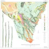
Geologic map of the Big Bend National Park, Brewster County, Texas | 1966 | Maxwell, R.A. | Bureau of Economic Geology | |
|
Limestone and dolomite resources, Lower Cretaceous rocks, Texas | 1966 | Limestone is one of the most important nonfuel mineral resources in Texas. Annual production exceeds $30 million; value added in the manufacture of such products as cement and lime amounts to about $100 million annually. |
Rodda, P.U., Fisher, W.L., Payne, W.R., Schofield, D.A. | Bureau of Economic Geology |
|
Sedimentary petrology and history of the Haymond Formation (Pennsylvanian), Marathon Basin, Texas | 1966 | This report treats the sedimentary petrology and history of the Haymond Formation, a monotonous sequence of interbedded sandstone and shale that has a maximum preserved thickness of 4,300 feet. |
McBride, E.F. | Bureau of Economic Geology |
|
Geology of Presidio Area, Presidio County, Texas | 1966 | Dietrich, J.W. | Bureau of Economic Geology | |
|
Nomenclature revision of basal Cretaceous rocks between the Colorado and Red Rivers, Texas | 1966 | Based on need for convenient, small-scale cartographic units, the basal Cretaceous rocks in Texas from Red River to Burnet County and on the Callahan Divide are herein divided into three distinctive lithologic sequences. |
Fisher, W.L., Rodda, P.U. | Bureau of Economic Geology |
|
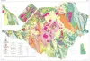
Geology of Black Gap Area, Brewster County, Texas | 1966 | The wedge-shaped Black Gap area in southern Brewsier County, Texas, occupies approximately 4,50 square miles east of the Big Bend National Park. |
St. John, D.E. | Bureau of Economic Geology |
|
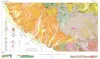
Geology of the Stonewall Quadrangle, Gillespie and Kendall Counties, Texas | 1965 | Stonewall quadrangle includes part of the southern margin of the Llano region and part of the eastern margin of the Edwards Plateau where most of the plateau suriace has been destroyed by erosion. |
Barnes, V.E. | Bureau of Economic Geology |
|
Oil and Water: Related Resource Problems of the Southwest. A Symposium | 1965 | This volume presents the texts of papers presented at a Symposium...sponsored by the Southwestern Federation of Geological Societies and The University of Texas in Austin, January 29, 1965. |
Bureau of Economic Geology | |
|
Bloating characteristics of East Texas clays | 1965 | Incidence of bloating among approximately 600 clay samples from East Texas, ranging in age from Gulfian (Late Cretaceous) to Recent, correlates principally with clay mineralogy-and pH--together an indication of bulk composition--and to a lesser extent with texture, loss on ignition, and content o |
Fisher, W.L., Garner, L.E. | Bureau of Economic Geology |
|
Texas Mineral Resources: Problems and Predictions | 1965 | When a reference is made to the mineral resources of Texas, most people think of oil and gas, and some few also of sulfur. And, of course, it is true that of the whopping $4.4 billion dollars’ worth of minerals produced in Texas in 1963, 92% was oil, gas, and natural gas liquids. |
Flawn, P.T. | Bureau of Economic Geology |