Bureau of Economic Geology Publications
| Title | Publication Year Sort ascending | Abstract | Author | Publisher | |
|---|---|---|---|---|---|
|
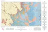
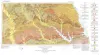
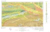
Geologic Atlas of Texas, Lubbock sheet (revised 1993) | 1967 | Geologic map that depicts surface geology of Crosby, Dickens, and King Counties and parts of Hale, Floyd, Motley, Cottle, King, Lubbock, Lynn, Garza, Kent, and Stonewall Counties. The Lubbock Sheet honors the late Dr. |
Eifler, G.K., Frye, J.C., Leonard, A.B., Hentz, T.F., Barnes, V.E. | Bureau of Economic Geology |
|
The Mineral Industry of Texas in 1966 | 1967 | Netzeband, F.F., Girard, R.M. | Bureau of Economic Geology | |
|
Lower Cretaceous sands of Texas: stratigraphy and resources | 1967 | Lower Cretaceous sands have long been important aquifers in Central, North-Central, and North Texas. In recent years these sands also have been sources of high-silica industrial or specialty-purpose sand. |
Fisher, W.L., Rodda, P.U. | Bureau of Economic Geology |
|
Sand resources of Texas gulf coast | 1967 | This report deals with the occurrence and potential production of industrial sand in the Gulf Coast area of Texas. The study area covers approximately 23,000 square miles underlain by alluvial, deltaic, beach, and eolian deposits of Pleistocene and Recent age. |
Garner, L.E. | Bureau of Economic Geology |
|
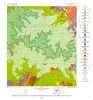
Geologic Atlas of Texas, Palestine sheet (revised 1993) | 1967 | Geologic map that depicts the surface geology of Nacogdoches, Shelby, San Augustine, Sabine, and Angelina Counties and parts of Anderson, Cherokee, Rusk, Newton, Jasper, Tyler, Polk, Trinity, Robertson, Madison, Leon, Freestone, and Panola Counties, Texas. |
Barnes, V.E., Humble Oil and Refining Co., Shell Oil Co., Pan American Petroleum Corp., Mobil Oil Co., Wright, A.C., McCallum, H.D., Wendlandt, E.A. | Bureau of Economic Geology |
|
Geology of the Cave Creek School Quadrangle, Gillespie County, Texas | 1967 | Barnes, V.E. | Bureau of Economic Geology | |
|
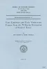
Late Cambrian and Early Ordovician faunas from the Wilberns Formation of central Texas | 1967 | The San Saba Member of the Wilberns Formation of central Texas is mostly coarse-grained, trilobitic limestone that grades eastward to dolomite and contains sandstone intervals in its westernmost exposures. |
Winston, Don, Nicholls, Harry | Bureau of Economic Geology |
|
Geology of the Monument Hill Quadrangle, Blanco County, Texas | 1967 | Barnes, V.E. | Bureau of Economic Geology | |
|
Geology of the Yeager Creek Quadrangle, Blanco and Hays Counties, Texas | 1967 | Barnes, V.E. | Bureau of Economic Geology | |
|
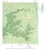
Geologic Atlas of Texas, Texarkana sheet (reprinted 1979 with base revised) | 1966 | Geologic map that depicts the surface geology of Lamar, Red River, Bowie, Delta, and Titus Counties and parts of Fannin, Hunt, Camp, Cass, Hopkins, Franklin, and Morris Counties, Texas. The 6-page booklet indicates geologic formations, abbreviations, and ages. |
Barnes, V.E., Humble Oil and Refining Co., Shell Oil Co., Pan American Petroleum Corp., Arkansas Geological and Conservation Commission, Oklahoma Geological Survey, McCallum, H.D., Wendlandt, E.A. | Bureau of Economic Geology |