Bureau of Economic Geology Publications
| Title | Publication Year Sort ascending | Abstract | Author | Publisher | |
|---|---|---|---|---|---|
|
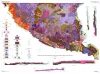
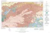
Geologic map of the Bofecillos Mountains area, Trans-Pecos Texas | 1970 | The Bofecillos Mountains area of Trans-Pecos Texas contains a Tertiary volcanic vent and a varied sequence of lava flows, tuff, ash-flow tuff, and associated conglomerate, sandstone, and mudrock; after most of the volcanic activity had ceased, the area was block faulled and later dissected into a |
McKnight, J.F. | Bureau of Economic Geology |
|
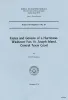
Facies and genesis of a hurricane-washover fan, St. Joseph Island, central Texas coast | 1970 | Two distinctive subaerial physiographic features that form a substantial portion, by area, of most barrier islands along the Texas coast are the washover fan and the tidal delta. Volumetrically, washover fan deposits and tidal delta deposits form a significant part of each barrier island. |
Andrews, P.B. | Bureau of Economic Geology |
|
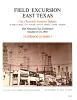
Field excursion East Texas -- clay, glauconite, ironstone deposits | 1969 | Brown, T.E., Newland, L.E., Campbell, D.H., Ehlmann, A.J. | Bureau of Economic Geology | |
|
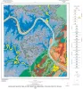
Geologic Map of the Austin West Quadrangle, Travis County, Texas | 1969 | The rocks exposed in the Austin West quadrangle are Cretaceous marine limestones and clays and Quaternary alluvial deposits. |
Rodda, P.U. | Bureau of Economic Geology |
|
Geologic Atlas of Texas, Amarillo sheet (reprinted 1981 with limited revisions) | 1969 | Geologic map that depicts the surface geology of Carson, Gray, and Wheeler Counties and parts of Moore, Hutchinson, Roberts, Hemphill, Potter, Randall, Armstrong, Donley, and Collingsworth Counties. |
Eifler, G.K., Phillips Petroleum Co., Humble Oil and Refining Co., Frye, J.C., Leonard, A.B., Knight, G.L., Hughes, C.D., Horn, P.H. | Bureau of Economic Geology |
|
Edwards Formation (Lower Cretaceous), Texas: dolomitization in a carbonate platform system | 1969 | Fisher, W.L., Rodda, P.U. | Bureau of Economic Geology | |
|
Sulfur in West Texas: its geology and economics | 1969 | Sulfur, along with salt, coal, and limestone, is one of the basic raw materials of the chemical industry. A nation’s per capita sulfur consumption is a reliable index to its chemical production and a rough index to its standard of living. |
Zimmerman, J.B., Thomas, Eugene | Bureau of Economic Geology |
|
Virgil and lower Wolfcamp repetitive environments and the depositional model, north-central Texas | 1969 | Virgil and lower Wolfcamp rocks on the Eastern Shelf in North-central Texas are composed of several intergradational depositional systems comprising 1,200 to 1,500 feet of off-lapping, predominantly terrigenous sediments. |
Brown, L.F., Jr. | Bureau of Economic Geology |
|
Geometry and distribution of fluvial and deltaic sandstones (Pennsylvanian and Permian), north-central Texas | 1969 | Upper Pensylvanian and lower Permian rocks of the Eastern Shelf in North-central Texas are composed of 10 to 15 repetitive sequences including open shelf, deltaic, fluvial, and interdeltaic depositional systems. |
Brown, L.F., Jr. | Bureau of Economic Geology |
|
The Mineral Industry of Texas in 1968 | 1969 | Netzeband, F.F., Girard, R.M. | Bureau of Economic Geology |