Publication Details
Geolocation:
Get the Publication
$25.00
Abstract/Description:
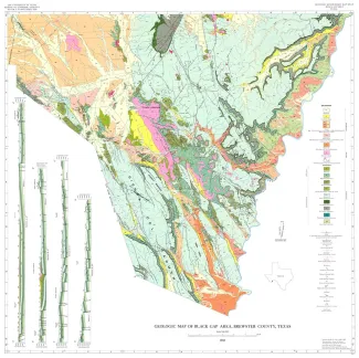
The wedge-shaped Black Gap area in southern Brewsier County, Texas, occupies approximately 4,50 square miles east of the Big Bend National Park. The southwestern boundary of the map area is the castcrn boundary of the Park; the southeastern boundary is the Rio Grande; the north boundary is drawn at lat. 29' 45' N. The area lies in the Trans-Pecos proxince and throughout this arid to semiarid region the climate, flora, and fauna are similar. The Black Gap region can be divided into four physiographic areas: (1) the topographically high and imposing Sierra del Carmen to the southwest, which is an area of stepped plateaus separated by steep, northwest-trending scarps; (2) the Cupola iWountain highland in the northeast corner of the map area; (3) a topographically low area extending from the Rio Grande northwest through the middle of the Black Gap area and characterized by low, steep-sided hills capped with basalt; and (4,) the gravel-covered lowland to the northwest which is an area of low, rounded hills.