Bureau of Economic Geology Publications
| Title | Publication Year Sort ascending | Abstract | Author | Publisher | |
|---|---|---|---|---|---|
|
Limitations of the Earth: A Compelling Focus for Geology | 1968 | Bureau of Economic Geology | ||
|
Proceedings, Fourth Forum on Geology of Industrial Minerals | 1968 | Papers in this volume were presented at the Fourth Forum on Geology of Industrial Minerals sponsored by the Bureau of Economic Geology, The University of Texas at Austin, on March 14 and 15, 1968. The program and meetings were organized and directed by co-chairmen W. L. Fisher and P. U. |
Brown, L.F., Jr. | Bureau of Economic Geology |
|
Lithology and petrology of the Gueydan (Catahoula) Formation in south Texas | 1968 | Tuff, tuffaceous sand and clay, bentonite, and sandstone containing abundant volcanic rock detritus are present in Gulf Coast Tertiary rocks ranging in age from Eocene to Pliocene. |
McBride, E.F., Lindemann, W.L., Freeman, P.S. | Bureau of Economic Geology |
|
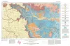
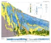
Geologic Atlas of Texas, Plainview sheet (revised 1992) | 1968 | Geologic map that depicts surface geology of Swisher, Briscoe, Hall, and Childress Counties and parts of Randall, Armstrong, Donley, Collingsworth, Hale, Floyd, Motley, and Cottle Counties. |
Barnes, V.E., Humble Oil and Refining Co., Shell Oil Co., Eifler, G.K., Knight, G.L., Hughes, C.D., Horn, P.H., Quackenbush, W.M. | Bureau of Economic Geology |
|
Geology of Apache Mountains, Trans-Pecos Texas | 1968 | Wood, J.W. | Bureau of Economic Geology | |
|
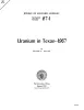
Uranium in Texas--1967 | 1967 | The uranium industry, born in boom in the late 1940's and early 1950's, fell upon hard times after about a decade of lusty growth as anticipated private markets failed to develop on schedule and the United States Atomic Energy Commission cut back and stretched out its purchase program. |
Flawn, P.T. | Bureau of Economic Geology |
|
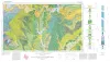
Geologic Atlas of Texas, Sherman sheet (revised 1991) | 1967 | Geologic map that depicts the surface geology of Montague, Cooke, Grayson, Wise, Denton, and Collin Counties and parts of Jack, Fannin, Hunt, and Clay Counties, Texas. The 16-page booklet indicates geologic formations, abbreviations, and ages. |
McGowen, J.H., Hentz, T.F., Owen, D.E., Pieper, M.K., Shelby, C.A., Barnes, V.E., Humble Oil and Refining Co., Pure Oil Co. | Bureau of Economic Geology |
|
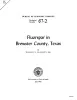
Fluorspar in Brewster County, Texas | 1967 | Since production of fluorspar began in northern Coahuila, Mexico, in 1950-51, thousands of tons of high-grade ore have been mined from numerous deposits situated 5 to 75 miles south of the Rio Grande. |
McAnulty, W.N. | Bureau of Economic Geology |
|
History of Geology at The University of Texas | 1967 | This history of geology at The University of Texas was prepared for the dedication of the new Geology Building, November 1967. It is a brief history; many details have been omitted. The names of most graduates and some faculty will not be found. |
Young, Keith | Bureau of Economic Geology |
|
Depositional systems in the Wilcox Group of Texas and their relationship to occurrence of oil and gas | 1967 | Regional investigation of the lower part of the Wilcox Group in Texas in outcrop and subsurface indicates seven principal depositional systems. These include: (1) Mt. |
Fisher, W.L., McGowen, J.H. | Bureau of Economic Geology |