Bureau of Economic Geology Publications
| Title | Publication Year Sort ascending | Abstract | Author | Publisher | |
|---|---|---|---|---|---|
|
The Mineral Industry of Texas in 1968 | 1969 | Netzeband, F.F., Girard, R.M. | Bureau of Economic Geology | |
|
Delta Systems in the Exploration for Oil and Gas | 1969 | This classic publication is a syllabus published in conjunction with a Research Colloquium of the Bureau of Economic Geology, August 27-29,1969. It includes discussion notes, 168 maps and other text figures, and a list of 321 selected references pertaining to modern and ancient delta systems. |
Fisher, W.L., Brown, L.F., Jr., Scott, A.J., McGowen, J.H. | Bureau of Economic Geology |
|
Palynology of the Eddleman Coal (Pennsylvanian) of north-central Texas | 1969 | The Eddleman Coal (Thrifty Formation, Cisco Group) in Young County, Texas, yielded a spore and pollen flora which was classified into 37 genera and 65 species. Ten species are regarded as new and are assigned to existing genera. A single new species is described and placed within a new genus. |
Stone, J.F. | Bureau of Economic Geology |
![Texas Mining Laws Pertaining to State Public Lands [as of 1968]](/files/styles/thumbnail/public/publication_covers/MM0033.jpg.webp?itok=yjiLWO-3)
|
Texas Mining Laws Pertaining to State Public Lands [as of 1968] | 1968 | Leach, C.H. | Bureau of Economic Geology | |
|
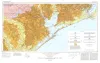
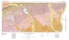
Geologic Atlas of Texas, Houston sheet (revised 1982) | 1968 | Geologic map that depicts the surface geology of Galveston and Chambers Counties and parts of Waller, Harris, Liberty, Jefferson, Orange, Brazoria, Matagorda, Wharton, and Fort Bend Counties. |
Barnes, V.E., Aronow, Saul, LeBlanc, R.J., Evans, F.G., Hinds, G.W., Holland, W.C., Van Siclen, D.C., Macon, J.W. | Bureau of Economic Geology |
|
Glen Rose cycles and facies, Paluxey River Valley, Somervell County, Texas | 1968 | Paleoenvironmental analysis of the alternating beds of the basal Cretaceous Glen Rose Formation in Central Texas indicates a cyclical alternation of subtidal through supratidal facies. |
Nagle, J.S. | Bureau of Economic Geology |
|
Geologic Atlas of Texas, Beaumont sheet (revised 1992) | 1968 | Geologic map that depicts the surface geology of Montgomery, San Jacinto, and Hardin Counties and parts of Madison, Trinity, Polk, Tyler, Jasper, Newton, Orange, Jefferson, Liberty, Harris, Waller, Grimes, Walker, and Robertson Counties. |
Barnes, V.E., Humble Oil and Refining Co., Shell Oil Co., Aronow, Saul, Shelby, C.A., Eargle, D.H., LeBlanc, R.J., Evans, F.G. | Bureau of Economic Geology |
| |
Geologic Atlas of Texas, Van Horn-El Paso sheet (revised 1983) | 1968 | Geologic map that depicts the surface geology of El Paso County and parts of Hudspeth. Jeff Davis, and Culberson Counties, Texas. The 12-page booklet indicates geologic formations, abbreviations, and ages. Published in honor of E. |
Barnes, V.E., Shell Oil Co., Cities Service Petroleum Co., Dietrich, J.W., Owen, D.E., Shelby, C.A., Macon, J.W., Bridges, L.W. | Bureau of Economic Geology |
|
Limitations of the Earth: A Compelling Focus for Geology | 1968 | Bureau of Economic Geology | ||
|
Proceedings, Fourth Forum on Geology of Industrial Minerals | 1968 | Papers in this volume were presented at the Fourth Forum on Geology of Industrial Minerals sponsored by the Bureau of Economic Geology, The University of Texas at Austin, on March 14 and 15, 1968. The program and meetings were organized and directed by co-chairmen W. L. Fisher and P. U. |
Brown, L.F., Jr. | Bureau of Economic Geology |