Bureau of Economic Geology Publications
| Title | Publication Year Sort ascending | Abstract | Author | Publisher | |
|---|---|---|---|---|---|
|
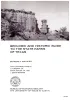
Geologic and Historic Guide to the State Parks of Texas | 1970 | Texas is no longer a frontier. The expansion of cities, industries, superhighways, and reservoirs, and changing land uses are fast absorbing the open spaces that once were so abundant in Texas. |
Maxwell, R.A. | Bureau of Economic Geology |
|
Geology of Southern Quitman Mountains, Hudspeth County, Texas | 1970 | The Quitman Mountains are part of a narrow mountain range that extends southeastward from near Sierra Blanca, Texas (85 miles southeast of El Paso, Texas), into northern Mexico. |
Jones, B.R., Reaser, D.F. | Bureau of Economic Geology |
|
Recent sediments of southeast Texas -- a field guide to the Brazos alluvial and deltaic plains and the Galveston barrier island complex | 1970 | This guidebook is a reprinting of a field guide prepared by Shell Development Company as part of a three-day industrial short course for full-time college teachers in geology, conducted from March 30 to April 1, 1970, by Shell Development Company, Houston, Texas, in cooperation with AGI Council o |
Bernard, H.A., Major, C.F., Parrott, B.S., LeBlanc, R.J. | Bureau of Economic Geology |
|
Correlation of Tertiary rock units, West Texas | 1970 | Tertiary rocks, including sandstone, conglomerate, shale, pyroclastics, tuff, and lava, are preserved in Big Bend National Park and in a much larger area to the west and northwest. Some of the rocks have distinctive characteristics that enable recognition by their lithology. |
Maxwell, R.A., Dietrich, J.W. | Bureau of Economic Geology |
|
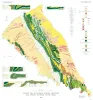
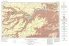
Geologic Atlas of Texas, Waco sheet | 1970 | Geologic maps that depicts the surface geology of McLennan, Limestone, and Falls Counties and parts of Bosque, Hill, Navarro, Freestone, Leon, Madison, Robertson, Milam, Bell, Lampasas, Coryell, and Hamilton Counties, Texas. |
Barnes, V.E., Humble Oil and Refining Co., Shell Oil Co., Mobil Oil Co., Proctor, C.V., Jr., McGowen, J.H., Haenggi, W.T., Hayward, O.T. | Bureau of Economic Geology |
|
Mineral Resources and Conservation in Texas | 1970 | The conservation movement has grown enormously in strength and breadth during the last decade as a result of widespread concern about natural resources and the quality of the environment. |
Flawn, P.T. | Bureau of Economic Geology |
|
The Mineral Industry of Texas in 1969 | 1970 | Jones, O.W., Netzeband, F.F., Girard, R.M. | Bureau of Economic Geology | |
|
Geological Considerations in Disposal of Solid Municipal Wastes in Texas | 1970 | In the United States the average citizen produces 6 to 8 pounds of solid wastes per day--this includes his personal contribution plus his pro-rata share of industrial and agricultural wastes. |
Flawn, P.T., Turk, L.J., Leach, C.H. | Bureau of Economic Geology |
|
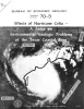
Effects of Hurricane Celia -- a focus on environmental geologic problems | 1970 | At 10 pm (CDT) on Friday, July 31, 1970, a tropical squall struck the western tip of Cuba causing property damage and the loss of 5 lives. Twelve hours later at 10 am (CDT), Saturday, August 1, the tropical depression had moved 150 miles northwest and had intensified into Tropical Storm Celia. |
McGowen, J.H., Groat, C.G., Brown, L.F., Jr., Fisher, W.L., Scott, A.J. | Bureau of Economic Geology |
|
Geologic Atlas of Texas, Perryton sheet (revised 1993) | 1970 | Geologic map that depicts the surface geology of Hansford, Ochiltree, and Lipscomb Counties and parts of Moore, Hutchinson, Roberts, Hemphill, and Sherman Counties. |
Barnes, V.E., Eifler, G.K., Fay, R.O., Quackenbush, W.M., Horn, P.H., Hughes, C.D. | Bureau of Economic Geology |