Bureau of Economic Geology Publications
| Title | Publication Year Sort ascending | Abstract | Author | Publisher | |
|---|---|---|---|---|---|
|
Uranium geology and mines, south Texas | 1971 | In recent years, exploration and mining of uranium have become a significant part of the Texas mineral scene, with Texas emerging as a leading uranium-producing state. At the end of 1970, Texas ranked third in reserves among the states, with ore reserves of 6.6 million tons. |
Eargle, D.H., Hinds, G.W., Weeks, A.M.D. | Bureau of Economic Geology |
|
Stratigraphy of Lower Cretaceous Trinity deposits of central Texas | 1971 | The stratigraphic record of the Lower Cretaceous Trinity Division in Central Texas, as revealed by extensive outcrop investigation, is that of a shallow sea transgressing the southern flank of the ancient Llano Uplift. |
Stricklin, F.L., Smith, C.I., Lozo, F.E. | Bureau of Economic Geology |
|
Van Horn Sandstone, West Texas: an alluvial fan model for mineral exploration | 1971 | The Van Horn Sandstone in southwestern Culberson and southeastern Hudspeth counties, Texas, was studied in cooperation with the U.S. |
McGowen, J.H., Groat, C.G. | Bureau of Economic Geology |
|
Depositional systems in the Woodbine Formation (Upper Cretaceous), northeast Texas | 1971 | The Woodbine Formation is composed largely of terrigenous sediment eroded from Paleozoic sedimentary and weakly metamorphosed sedimentary rocks of the Ouachita Mountains in southern Oklahoma and Arkansas and subsequently deposited in a complex of nearshore environments along the margins of the br |
Oliver, W.B. | Bureau of Economic Geology |
|
Resource Capability Units: Their Utility in Land- and Water-Use Management with Examples from the Texas Coastal Zone | 1971 | A resource capability unit is an environmental entity--land, water, area of active process, or biota--defined in terms of the nature, degree of activity, or use it can sustain without losing an acceptable level of environmental quality. |
Brown, L.F., Jr., Fisher, W.L., Erxleben, A.W., McGowen, J.H. | Bureau of Economic Geology |
|
Lower Cretaceous Stratigraphy, Northern Coahuila, Mexico | 1970 | This report presents stratigraphic data and interpretations pertaining to the origin of a continental shelf-ocean basin sedimentary complex developed during Lower Cretaceous time in northern Coahuila, Mexico. |
Smith, C.I. | Bureau of Economic Geology |
|
Physiographic Features and Stratification Types of Coarse-Grained Point Bars: Modern and Ancient Examples | 1970 | Primary sedimentary structures in modern point-bar deposits of the Amite River in Louisiana and the Colorado River in Texas are analogous to features observed in Eocene Simsboro and Pleistocene Colorado River deposits of the Texas Gulf Coastal Plain. |
McGowen, J.H., Garner, L.E. | Bureau of Economic Geology |
|
Trilobites of the Upper Cambrian Ptychaspid biomere, Wilberns Formation, central Texas | 1970 | Trilobites collected during the past 20 years from the Morgan Creek, Point Peak, and San Saba Members of the Wilberns Formation comprise 89 species assigned to 45 genera belonging to zones of the upper Franconian and Trempealeauan Stages of the Upper Cambrian Croixan Series. |
Longacre, S.A. | Bureau of Economic Geology |
|
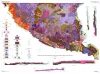
Geologic map of the Bofecillos Mountains area, Trans-Pecos Texas | 1970 | The Bofecillos Mountains area of Trans-Pecos Texas contains a Tertiary volcanic vent and a varied sequence of lava flows, tuff, ash-flow tuff, and associated conglomerate, sandstone, and mudrock; after most of the volcanic activity had ceased, the area was block faulled and later dissected into a |
McKnight, J.F. | Bureau of Economic Geology |
|
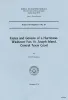
Facies and genesis of a hurricane-washover fan, St. Joseph Island, central Texas coast | 1970 | Two distinctive subaerial physiographic features that form a substantial portion, by area, of most barrier islands along the Texas coast are the washover fan and the tidal delta. Volumetrically, washover fan deposits and tidal delta deposits form a significant part of each barrier island. |
Andrews, P.B. | Bureau of Economic Geology |