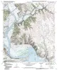
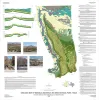
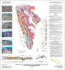
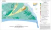
Publication Search

Bureau of Economic Geology Publications

Title Publication Year Sort ascending Abstract Author Publisher
General Soil Map of Texas General Soil Map of Texas 2008 University of Texas at Austin, Bureau of Economic Geology Bureau of Economic Geology
Leaning Forward, A Memoir Leaning Forward, A Memoir 2008

William L. Fisher is the Leonidas T. Barrow Centennial Chair in Mineral Resources and Professor Emeritus at The University of Texas at Austin, in the Department of Geological Sciences.

Fisher, W.L. Bureau of Economic Geology
Geologic map of the Glenn Spring quadrangle, Big Bend National Park, Texas Geologic map of the Glenn Spring quadrangle, Big Bend National Park, Texas 2008 Collins, E.W., Muehlberger, W.R., Dickerson, P.W. Bureau of Economic Geology
Geologic map of the Southeast Part of the Austin, Texas, 30x60 Minute Quadrangle; Central Texas Population Corridor Encompassing Bastrop and Smithville Geologic map of the Southeast Part of the Austin, Texas, 30x60 Minute Quadrangle; Central Texas Population Corridor Encompassing Bastrop and Smithville 2008 Collins, E.W. Bureau of Economic Geology
Sequence Stratigraphy and Depositional Systems of the Woodbine Group in East Texas Field: Core Workshop Sequence Stratigraphy and Depositional Systems of the Woodbine Group in East Texas Field: Core Workshop 2008 Ambrose, W.A., Hentz, T.F., Loucks, R.G., Clift, S.J., Potter, E.C., Bonnaffé, F. Bureau of Economic Geology
Industrial Minerals of Texas Industrial Minerals of Texas 2008 Kyle, J.R. Bureau of Economic Geology
Geologic map of the Bryan West quadrangle, Texas Geologic map of the Bryan West quadrangle, Texas 2007 Collins, E.W. Bureau of Economic Geology
Reservoir Geology, Structural Architecture, and Sequence Stratigraphy of a Growth-Faulted Subbasin: Oligocene Lower Frio Formation, Red Fish Bay Area, South Texas Gulf Coast Reservoir Geology, Structural Architecture, and Sequence Stratigraphy of a Growth-Faulted Subbasin: Oligocene Lower Frio Formation, Red Fish Bay Area, South Texas Gulf Coast 2007

An integrated study using 3D seismic, wireline logs, and core analyses was conducted to establish new strategies for exploring compartmentalized, lowstand, prograding deltaic systems.

Hammes, Ursula, Loucks, R.G., Brown, L.F., Jr., Treviño, R.H., Montoya, Patricia, Remington, R.L. Bureau of Economic Geology
Geologic map of the Del Rio, Texas, area Geologic map of the Del Rio, Texas, area 2007 Collins, E.W. Bureau of Economic Geology
Geoenvironmental map of southwest Bolivar Peninsula, Bolivar and Flake quadrangles, Texas Gulf of Mexico Coast Geoenvironmental map of southwest Bolivar Peninsula, Bolivar and Flake quadrangles, Texas Gulf of Mexico Coast 2007 Tremblay, T.A., White, W.A., Waldinger, R.L., Collins, E.W. Bureau of Economic Geology