|
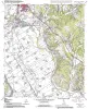
Geologic map of the Hearne South quadrangle, Texas |
2006 |
|
Collins, E.W. |
Bureau of Economic Geology |
|
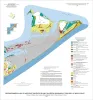
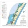
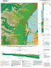
Geo-Environmental map of Northeast Galveston Island, Galveston quadrangle, Texas |
2006 |
|
Tremblay, T.A., Gibeaut, J.C., Waldinger, R.L., White, W.A., Collins, E.W. |
Bureau of Economic Geology |
|
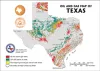
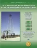
Oil and Gas Map of Texas Postcard |
2006 |
|
|
Bureau of Economic Geology |
|
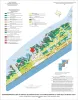
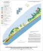
Geo-Environmental map of Central Galveston Island, Lake Como quadrangle, Texas |
2006 |
|
Tremblay, T.A., Gibeaut, J.C., Waldinger, R.L., White, W.A., Collins, E.W. |
Bureau of Economic Geology |
|
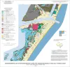
Geo-Environmental map of Southwest Galveston Island, San Luis Pass and Sea Isle quadrangles, Texas Gulf of Mexico |
2006 |
|
Tremblay, T.A., Gibeaut, J.C., Waldinger, R.L., White, W.A., Collins, E.W. |
Bureau of Economic Geology |
|
Geo-Environmental map of Northern Mustang Island, Port Aransas quadrangle, Texas Gulf of Mexico Coast |
2006 |
|
Tremblay, T.A., Gibeaut, J.C., Waldinger, R.L., White, W.A., Collins, E.W. |
Bureau of Economic Geology |
|
Geo-Environmental map of Southern Mustang Island, Crane Islands NW quadrangle, Texas Gulf of Mexico Coast |
2006 |
|
Tremblay, T.A., Gibeaut, J.C., Waldinger, R.L., White, W.A., Collins, E.W. |
Bureau of Economic Geology |
|
Play Analysis and Digital Portfolio of Major Oil Reservoirs in the Permian Basin |
2005 |
|
Dutton, S.P., Broadhead, R.F., Breton, C.L., Raatz, W.D., Ruppel, S.C., Kerans, Charles |
Bureau of Economic Geology |
|
Geologic map of the west half of the Taylor, Texas, 30 X 60 minute quadrangle: central Texas urban corridor, encompassing Round Rock, Georgetown, Salado, Briggs, Liberty Hill, and Leander |
2005 |
|
Collins, E.W. |
Bureau of Economic Geology |
|
Petrographic Characterization of the Barnett Shale, Fort Worth Basin, Texas: Thesis and Appendices |
2005 |
|
Papazis, P.K. |
Bureau of Economic Geology |