Bureau of Economic Geology Publications
|
Title |
Publication Year
Sort ascending
|
Abstract |
Author |
Publisher |
|
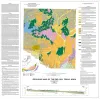
Geologic map of the Del Rio, Texas, area |
2007 |
|
Collins, E.W. |
Bureau of Economic Geology |
|
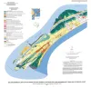
Geoenvironmental map of southwest Bolivar Peninsula, Bolivar and Flake quadrangles, Texas Gulf of Mexico Coast |
2007 |
|
Tremblay, T.A., White, W.A., Waldinger, R.L., Collins, E.W. |
Bureau of Economic Geology |
|
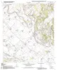
Geologic map of the Chances Store quadrangle, Texas |
2007 |
|
Collins, E.W. |
Bureau of Economic Geology |
|
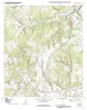
Geologic map of the Goodwill quadrangle, Texas |
2007 |
|
Collins, E.W. |
Bureau of Economic Geology |
|
Geologic map of the Mumford quadrangle, Texas |
2007 |
|
Collins, E.W. |
Bureau of Economic Geology |
|
Geologic map of the Baileyville quadrangle, Texas |
2006 |
|
Collins, E.W. |
Bureau of Economic Geology |
|
Geologic map of the Hammond quadrangle, Texas |
2006 |
|
Collins, E.W. |
Bureau of Economic Geology |
|
Geologic map of the Maysfield quadrangle, Texas |
2006 |
|
Collins, E.W. |
Bureau of Economic Geology |
|
Geologic map of the Calvert quadrangle, Texas |
2006 |
|
Collins, E.W. |
Bureau of Economic Geology |
|
Geologic map of the Gause quadrangle, Texas |
2006 |
|
Collins, E.W. |
Bureau of Economic Geology |