Bureau of Economic Geology Publications
| Title | Publication Year Sort ascending | Abstract | Author | Publisher | |
|---|---|---|---|---|---|
|
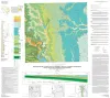
Geologic map of the Nueces Delta-Annaville and Odem quadrangles, Texas Gulf Coast | 2012 | Paine, J.G., Collins, E.W. | Bureau of Economic Geology | |
|
Geologic map of the Gainesville North quadrangle, Texas | 2012 | Collins, E.W. | Bureau of Economic Geology | |
|
Wolfberry (Wolfcampian-Leonardian) Deep-Water Depositional Systems in the Midland Basin: Stratigraphy, Lithofacies, Reservoirs, and Source Rocks | 2012 | The Wolfberry play in West Texas combines favorable geology with innovative completion practices to form one of the largest unconventional oil plays in the United States. Wolfberry wells produced almost 55 million barrels of oil in 2011, and that figure could double in a few years. |
Hamlin, H.S., Baumgardner, R.W., Jr. | Bureau of Economic Geology |
|
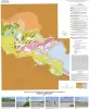
Geologic Maps of the Upper Cretaceous and Tertiary Strata, Big Bend National Park, Texas | 2011 | This six-sheet set of oversize colorful geologic maps and cross sections presents new interpretations on the outcrop pattern and complex structure within the Upper Cretaceous Del Rio, Buda, Boquillas, Pen, Aguja, Javelina, and Cretaceous-Tertiary Black Peaks Formations of Big Bend National Park. |
Cooper, R.W. | Bureau of Economic Geology |
|
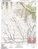
Geologic map of the east part of Cleburne, Texas, 30 x 60 minute quadrangle: South Fort Worth-Interstate 35W corridor | 2011 | Collins, E.W., Baumgardner, R.W., Jr. | Bureau of Economic Geology | |
|
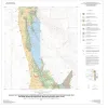
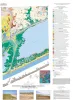
Geoenvironmental map of Matagorda - Matagorda SW quadrangles, Texas Gulf of Mexico Coast | 2011 | Tremblay, T.A., Collins, E.W., Paine, J.G. | Bureau of Economic Geology | |
|
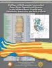
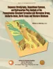
Sequence Stratigraphy, Depositional Systems, and Hydrocarbon Play Analysis of the Pennsylvanian Cleveland Formation and Marmaton Group, Anadarko Basin, North Texas and Western Oklahoma | 2011 | This report provides a detailed review of the stratigraphic and structural attributes and controls on productivity and future potential of the Cleveland Formation and Marmaton Group by integrating chronostratigraphic, depositional-facies, and play analysis. |
Ambrose, W.A. | Bureau of Economic Geology |
|
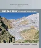
The Salt Mine: A Digital Atlas of Salt Tectonics | 2011 | This publication helps scientists quickly sort through the entire spectrum of knowledge of salt tectonics, isolate relevant information, and find pathways to more-detailed information. |
Hudec, M.R., Jackson, M.P.A. | Bureau of Economic Geology |
|
Geologic map of the Brazos Point quadrangle, Texas | 2010 | Collins, E.W. | Bureau of Economic Geology | |
|
Geologic map of the Lakeside Village quadrangle, Texas | 2010 | Collins, E.W. | Bureau of Economic Geology |