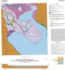
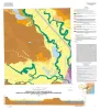
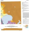
Publication Search

Bureau of Economic Geology Publications

Title Publication Year Sort ascending Abstract Author Publisher
Sequence Stratigraphy, Depositional Systems, and Hydrocarbon Play Analysis of the Pennsylvanian Cleveland Formation and Marmaton Group, Anadarko Basin, North Texas and Western Oklahoma Sequence Stratigraphy, Depositional Systems, and Hydrocarbon Play Analysis of the Pennsylvanian Cleveland Formation and Marmaton Group, Anadarko Basin, North Texas and Western Oklahoma 2011

This report provides a detailed review of the stratigraphic and structural attributes and controls on productivity and future potential of the Cleveland Formation and Marmaton Group by integrating chronostratigraphic, depositional-facies, and play analysis.

Ambrose, W.A. Bureau of Economic Geology
The Salt Mine: A Digital Atlas of Salt Tectonics The Salt Mine: A Digital Atlas of Salt Tectonics 2011

This publication helps scientists quickly sort through the entire spectrum of knowledge of salt tectonics, isolate relevant information, and find pathways to more-detailed information.

Hudec, M.R., Jackson, M.P.A. Bureau of Economic Geology
Geologic map of the Keene quadrangle, Texas Geologic map of the Keene quadrangle, Texas 2010 Collins, E.W. Bureau of Economic Geology
Ecoregions of Texas Ecoregions of Texas 2010 University of Texas at Austin, Bureau of Economic Geology Bureau of Economic Geology
Sequence Stratigraphy, Depositional Facies, and Reservoir Attributes of the Upper Cretaceous Woodbine Group, East Texas Field Sequence Stratigraphy, Depositional Facies, and Reservoir Attributes of the Upper Cretaceous Woodbine Group, East Texas Field 2010

Although the mature, supergiant East Texas field on the west flank of the Sabine Uplift has been producing from the Upper Cretaceous (Cenomanian) siliciclastic Woodbine Group for more than 75 years, no modern comprehensive geologic study of it has been completed.

Hentz, T.F. Bureau of Economic Geology
Geologic map of the Brazos Point quadrangle, Texas Geologic map of the Brazos Point quadrangle, Texas 2010 Collins, E.W. Bureau of Economic Geology
Geologic map of the Lakeside Village quadrangle, Texas Geologic map of the Lakeside Village quadrangle, Texas 2010 Collins, E.W. Bureau of Economic Geology
Geologic map of Mariscal Mountain, Big Bend National Park, Texas Geologic map of Mariscal Mountain, Big Bend National Park, Texas 2010 Dickerson, P.W., Muehlberger, W.R., Collins, E.W. Bureau of Economic Geology
Geologic map of the Blanton quadrangle, Texas Geologic map of the Blanton quadrangle, Texas 2010 Collins, E.W. Bureau of Economic Geology
Geologic map of the Southern Franklin Mountains, El Paso, Texas, with focus on collapse breccia Geologic map of the Southern Franklin Mountains, El Paso, Texas, with focus on collapse breccia 2010 Lucia, F.J. Bureau of Economic Geology