Publication Search

Bureau of Economic Geology Publications

Title Publication Year Sort ascending Abstract Author Publisher
Geologic map of the Morgan quadrangle, Texas Geologic map of the Morgan quadrangle, Texas 2009 Collins, E.W. Bureau of Economic Geology
Supplement to Guidebook 14 Supplement to Guidebook 14 2009 Brown, L.F., Jr., Ambrose, W.A., Carr, D.L. Bureau of Economic Geology
Geoenvironmental map of Big Hill Bayou quadrangle, Texas, Gulf of Mexico Coast Geoenvironmental map of Big Hill Bayou quadrangle, Texas, Gulf of Mexico Coast 2009 Tremblay, T.A., Caudle, T.L., White, W.A. Bureau of Economic Geology
Geoenvironmental map of Port Arthur South quadrangle, Texas, Gulf of Mexico Coast Geoenvironmental map of Port Arthur South quadrangle, Texas, Gulf of Mexico Coast 2009 Tremblay, T.A., Caudle, T.L., White, W.A. Bureau of Economic Geology
Geoenvironmental map of Clam Lake quadrangle, Texas, Gulf of Mexico Coast Geoenvironmental map of Clam Lake quadrangle, Texas, Gulf of Mexico Coast 2009 Tremblay, T.A., White, W.A., Caudle, T.L. Bureau of Economic Geology
Geoenvironmental map of Sabine Pass and Texas Point quadrangles, Texas, Gulf of Mexico Coast Geoenvironmental map of Sabine Pass and Texas Point quadrangles, Texas, Gulf of Mexico Coast 2009 Tremblay, T.A., White, W.A., Caudle, T.L. Bureau of Economic Geology
Chronostratigraphy of Cenozoic Depositional Sequences and Systems Tracts: A Wheeler Chart of the Northwest Margin of the Gulf of Mexico Basin Chronostratigraphy of Cenozoic Depositional Sequences and Systems Tracts: A Wheeler Chart of the Northwest Margin of the Gulf of Mexico Basin 2009

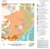
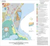
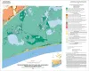
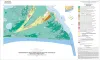
A chronostratigraphic chart (Wheeler chart) was constructed of the Cenozoic strata of the northwest margin of the Gulf of Mexico basin (Texas coastal area).

Brown, L.F., Jr., Loucks, R.G. Bureau of Economic Geology
Geologic map of the Blum quadrangle, Texas Geologic map of the Blum quadrangle, Texas 2009 Collins, E.W. Bureau of Economic Geology
Geologic map of the Glenn Spring quadrangle, Big Bend National Park, Texas Geologic map of the Glenn Spring quadrangle, Big Bend National Park, Texas 2008 Collins, E.W., Muehlberger, W.R., Dickerson, P.W. Bureau of Economic Geology
Geologic map of the Southeast Part of the Austin, Texas, 30x60 Minute Quadrangle; Central Texas Population Corridor Encompassing Bastrop and Smithville Geologic map of the Southeast Part of the Austin, Texas, 30x60 Minute Quadrangle; Central Texas Population Corridor Encompassing Bastrop and Smithville 2008 Collins, E.W. Bureau of Economic Geology