Publications by Barnes, V.E.
| Title | Publication Year Sort ascending | Abstract | Author | Series | Publisher | |
|---|---|---|---|---|---|---|
|
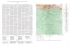
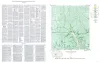
Geologic map of the Hilltop Quadrangle, Gillespie, Llano, and Mason Counties, Texas | 1952 | Barnes, V.E. | Geologic Quadrangle Map | Bureau of Economic Geology | |
|
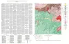
Geologic Map of the Crabapple Creek Quadrangle Gillespie and Llano Counties, Texas | 1952 | Barnes, V.E. | Geologic Quadrangle Map | Bureau of Economic Geology | |
|
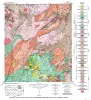
Geologic map of the Willow City quadrangle, Gillespie and Llano Counties, Texas | 1952 | Barnes, V.E. | Geologic Quadrangle Map | Bureau of Economic Geology | |
|
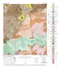
Geologic Map of the Blowout Quadrangle, Blanco, Gillespie, and Llano Counties, Texas | 1952 | Barnes, V.E. | Geologic Quadrangle Map | Bureau of Economic Geology | |
|
Geologic map of the Spring Creek Quadrangle, Gillespie County, Texas | 1952 | Barnes, V.E. | Geologic Quadrangle Map | Bureau of Economic Geology | |
|
Utilization of Texas Serpentine | 1950 | Barnes, V.E., Shock, D.A., Cunningham, W.A. | UT Publication | ||
|
Iron ore in the Llano region, central Texas | 1949 | The magnetic iron-ore prospects of the Llano region of central Texas were investigated in a program which combined dip-needle and gravity-meter surveys by the Bureau of Economic Geology of The University of Texas and the U.S. Geological Survey with exploration by the U.S. Bureau of Mines. |
Barnes, V.E., Goldich, S.S., Romberg, Frederick | Report of Investigations | Bureau of Economic Geology |
|
Correlation of gravity observations with the geology of the Coal Creek serpentine mass, Blanco and Gillespie Counties, Texas | 1949 | Gravitational observations were made of the pre-Cambrian Coal Creek serpentine mass in Blanco and Gillespie Counties, Texas, the geology of which had been mapped previously. |
Romberg, Frederick, Barnes, V.E. | Report of Investigations | Bureau of Economic Geology |

|
Ouachita facies in central Texas | 1948 | Steeply dipping shales and interbedded sandstones presumably of the Ouachita facies have been discovered along the Colorado River in Burnet and Travis counties, Texas. Previously the Ouachita facies was known in Texas only from bore-hole samples. |
Barnes, V.E. | Report of Investigations | Bureau of Economic Geology |
|
The Ellenburger Group of Central Texas | 1946 | Cloud, P.E., Jr., Barnes, V.E. | UT Publication |