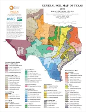
Publication Year
2008
Publisher
Series
Thematic Maps
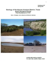
Publication Year
2007
Publisher
Series
Austin Geological Society
Abstract
D. Hoye Eargle, George Pinkley, and Paul de Vergie led and co-authored the first field trip to the Karnes Uranium District for the South Texas Geological Society in 1958, nearly 50 years ago. Since then, various field trips have been held to this area by different groups. Additionally, there are a wealth of research and papers on the uranium geology of the area, mostly by the USGS, and the University of Texas/Bureau of Economic Geology. A few of the early geologists who worked there in the 1950s are still working and have some fascinating stories of those times.
Publication Year
2007
Series
Gulf Coast Association of Geological Societies
Publication Year
2007
Publisher
Series
Austin Geological Society
Publication Year
2007
Series
Annual Reports
Abstract
Annual report for the Bureau of Economic Geology 2007