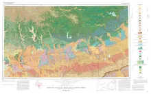
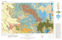
Geologic map that depicts the surface geology of Comal, Bandera, Bexar, and Medina Counties and parts of Real, Kerr, Kendall, Hays, Guadalupe, Wilson, Atascosa, Frio, Zavala, and Uvalde Counties, Texas. The 9-page booklet indicates geologic formations, abbreviations, and ages.
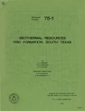
A preliminary study of the Frio sand distribution and formation temperatures and pressures was undertaken in order to define prospective areas in which a more detailed reservoir analysis is necessary prior to the selection of a site for a geothermal well.
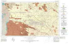
Geologic map that depicts the surface geology of Cochran and Hockley Counties and parts of Bailey, Lamb, Yoakum, Terry, Hale, Lubbock, and Lynn Counties.
The purpose of this paper is to present a system of encoding rock data for multiple uses that include (1) mapping subsurface stratigraphy for economic exploration, (2) cataloging borings used in subsurface waste disposal, and (3) building a library of natural resource information. Regional surface and subsurface stratigraphic studies for exploration in sedimentary basins commonly require the handling of numerous columnar sections that display rock descriptions collected from both outcrop and borings.
Geologic map that depicts the surface geology of Borden, Scurry, Fisher, Martin, Howard, Mitchell, and Nolan Counties and parts of Glasscock, Sterling, Coke, Runnels, Taylor, Jones, Dawson, Martin, Lynn, Garza, Kent, and Stonewall Counties. The 6-page booklet indicates geologic formations, abbreviations, and ages.