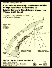
Examination of porosity and permeability (reservoir quality) data, as determined by whole core, acoustic log, and petrographic analyses of lower Tertiary sandstones along the Texas Gulf Coast, made it possible to delineate areas most favorable for development of hydrocarbon reservoirs. Deep (about 3,350 m [11,000 ft] or greater) Wilcox sandstones exhibit no systematic regional reservoir-quality trends. Along the lower and parts of the middle and upper Texas Gulf Coast, deep Wilcox sandstones are tight, but in other parts of the middle and upper Texas Gulf Coast, porosity exists at depth.
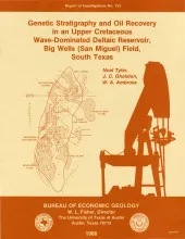
The Big Wells (San Miguel) reservoir in Dimmit and Zavala Counties, South Texas, produces from a broadly lenticular, wave-dominated deltaic sandstone encased in prodelta and shelf mudstones. An updip porosity pinch-out coincides with a gentle undulation on a uniformly gulfward-dipping monocline and forms a structurally modified stratigraphic trap. The reservoir is relatively tight and has average porosity of 21 percent and average permeability of 6 md; wells require fracturing to stimulate production.
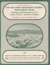
The Van Horn Mountains caldera is a small (~10-km2) igneous center in the Trans-Pecos volcanic province. The caldera formed 37 to 38 mya during eruption of the first of two ash-flow tuffs related to the caldera. Part of the first tuff ponded within the caldera; the lower marker horizon of the Chambers Tuff in the Sierra Vieja south of the Van Horn Mountains is probably the correlative outflow tuff. Following collapse, the caldera was partly filled by a heterogeneous assemblage of air-fall tuff, tuffaceous sediment, and possible ash-flow tuff.
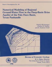
A conceptual hydrogeologic model of the Palo Duro Basin, Texas Panhandle, subdivides the basin into three hydrogeologic units: (1) the shallow Ogallala and Dockum aquifers (Upper aquifer), (2) the Permian evaporite aquitard (Evaporite aquitard), and (3) the deep, confined, underpressured, principally Permian and Pennsylvanian brine aquifer (Deep-Basin Brine aquifer).
Topographically controlled ground-water-basin divides, established during the Pleistocene by erosion of the Pecos and Canadian River valleys, prevent ground-water recharge in the outcrop of the Triassic Dockum Group from entering the confined part of the aquifer in the Dockum Group beneath the Southern High Plains in the Texas Panhandle and eastern New Mexico. Ground water in the confined aquifer was probably recharged from precipitation at higher elevations in eastern New Mexico before thick deposits of Dockum Group sandstones were eroded.