Geologic Maps Publications
| Title | Publication Year Sort ascending | Abstract | Author | Series | Publisher | |
|---|---|---|---|---|---|---|
|
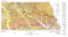
Geologic Atlas of Texas, Palestine sheet (revised 1993) | 1967 | Geologic map that depicts the surface geology of Nacogdoches, Shelby, San Augustine, Sabine, and Angelina Counties and parts of Anderson, Cherokee, Rusk, Newton, Jasper, Tyler, Polk, Trinity, Robertson, Madison, Leon, Freestone, and Panola Counties, Texas. |
Barnes, V.E., Humble Oil and Refining Co., Shell Oil Co., Pan American Petroleum Corp., Mobil Oil Co., Wright, A.C., McCallum, H.D., Wendlandt, E.A. | Geologic Atlas of Texas | Bureau of Economic Geology |
|
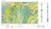
Geologic Atlas of Texas, Sherman sheet (revised 1991) | 1967 | Geologic map that depicts the surface geology of Montague, Cooke, Grayson, Wise, Denton, and Collin Counties and parts of Jack, Fannin, Hunt, and Clay Counties, Texas. The 16-page booklet indicates geologic formations, abbreviations, and ages. |
McGowen, J.H., Hentz, T.F., Owen, D.E., Pieper, M.K., Shelby, C.A., Barnes, V.E., Humble Oil and Refining Co., Pure Oil Co. | Geologic Atlas of Texas | Bureau of Economic Geology |
|
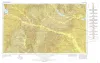
Geologic map of the Big Bend National Park, Brewster County, Texas | 1966 | Maxwell, R.A. | Miscellaneous Map | Bureau of Economic Geology | |

|
Geologic Atlas of Texas, Texarkana sheet (reprinted 1979 with base revised) | 1966 | Geologic map that depicts the surface geology of Lamar, Red River, Bowie, Delta, and Titus Counties and parts of Fannin, Hunt, Camp, Cass, Hopkins, Franklin, and Morris Counties, Texas. The 6-page booklet indicates geologic formations, abbreviations, and ages. |
Barnes, V.E., Humble Oil and Refining Co., Shell Oil Co., Pan American Petroleum Corp., Arkansas Geological and Conservation Commission, Oklahoma Geological Survey, McCallum, H.D., Wendlandt, E.A. | Geologic Atlas of Texas | Bureau of Economic Geology |
|
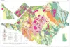
Geologic Atlas of Texas, Tyler sheet | 1964 | Geologic map that depicts the surface geology of Rains, Wood, Upshur, Marion, Harrison, Smith, and Gregg Counties and parts of Camp, Cass, Panola, Rusk, Cherokee, Anderson, Henderson, Van Zandt, Hunt, Morris, Franklin, and Hopkins Counties, Texas. |
Barnes, V.E., Shell Oil Co., Humble Oil and Refining Co., Mobil Oil Co., Pan American Petroleum Corp., Eaton, R.W., Wright, A.C., McCallum, H.D. | Geologic Atlas of Texas | Bureau of Economic Geology |
|
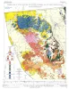
Geologic map of Southeastern Llano Uplift, Llano, Burnet, Blanco, and Gillespie counties, Texas | 1963 | McGehee, R.V. | Miscellaneous Map | Bureau of Economic Geology | |
|
Index to Areal Geologic Maps in Texas | 1963 | In planning for a modern geologic map of the State (scale 1:250,000), a bibliography of published and unpublished geologic maps of areas in Texas was compiled under the direction of Virgil E. Barnes, Director of the Geologic Atlas Project of the Bureau of Economic Geology. |
Brown, T.E. | Miscellaneous Map | |
|
Geologic Maps, Central Texas (selected areas), 1957 and 1959 | 1957 | Fourteen black-and-white geologic maps prepared in 1957 and 1959 and obtained from the Department of Geological Sciences, University of Texas, and sold by the Bureau of Economic Geology. Geology compiled by F. L. Whitney; drafted by S. Espey, W. M. Strong, or W. L. Brooks; edited by K. P. |
Whitney, F.L. | Miscellaneous Map | Bureau of Economic Geology |
|
Geologic map of Wylie Mountains and Vicinity, Culberson and Jeff Davis Counties, Texas | 1957 | Hay-Roe, Hugh | Geologic Quadrangle Map | Bureau of Economic Geology | |
|
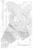
Geologic map of the Fall Prong Quadrangle, Kimble, Gillespie and Mason Counties, Texas | 1956 | Fall Prong quadrangle is in the marginal portion of the Edwards Plateau near the southeastern corner of the Llano region. Almost three-quarters of the quadrangle is within the Edwards Plateau, and the rest consists of valleys of the Llano basin cutting back into the plateau. |
Barnes, V.E. | Geologic Quadrangle Map | Bureau of Economic Geology |