Publication Details
Geolocation:
Get the Publication
$11.50
Abstract/Description:
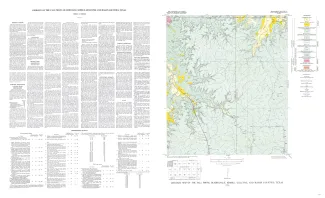
Fall Prong quadrangle is in the marginal portion of the Edwards Plateau near the southeastern corner of the Llano region. Almost three-quarters of the quadrangle is within the Edwards Plateau, and the rest consists of valleys of the Llano basin cutting back into the plateau.
The geology of the Fall Prong quadrangle is shown on a planimetric map; the only topographic map available is the reconnaissance 30-minute Kerrville quadrangle. Elevations ranging between 1,723 and 2,245 feet were determined during traversing for control, but the lowest elevation was not reached. However, it is estimated that the relief within the quadrangle is about 545 feet, ranging between about 1,700 and 2,245 feet.
The quadrangle is entirely within the Llano River drainage basin. Most of it drains into the James River via Little Devils River, with important branches being Fall Prong and White Oak Creek. Salt Branch in the northwestern corner flows directly to James River. A small area in the southeastern part of the quadrangle drains into Threadgill Creek and reaches the Llano River via Beaver Creek.
The Fall Prong quadrangle is well up on the southwestern side of the Llano uplift and is covered by Cretaceous rocks which crop out over the entire quadrangle except in the northwestern part where Cambrian and Ordovician rocks appear. One fault formed during the Ouachita orogeny (Barnes, 1948) is exposed. The Cretaceous rocks are essentially horizontal and may dip as much as 6 feet per mile southeastward in most of the quadrangle.
Broader discussions of the stratigraphic, structural, economic, and geophysical problems of the region are in references cited below. This publication on the Fall Prong quadrangle is one of a series of similar publications, an index to which is shown on the opposite page. The reader is referred to the index map to locate other quadrangles mentioned in the present text.