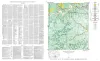
Geologic Maps Publications
| Title | Publication Year Sort ascending | Abstract | Author | Series | Publisher | |
|---|---|---|---|---|---|---|
|
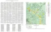
Geologic map of the Willow City quadrangle, Gillespie and Llano Counties, Texas | 1952 | Barnes, V.E. | Geologic Quadrangle Map | Bureau of Economic Geology | |
|
Geologic Map of the Blowout Quadrangle, Blanco, Gillespie, and Llano Counties, Texas | 1952 | Barnes, V.E. | Geologic Quadrangle Map | Bureau of Economic Geology | |
|
Geologic map of the Spring Creek Quadrangle, Gillespie County, Texas | 1952 | Barnes, V.E. | Geologic Quadrangle Map | Bureau of Economic Geology | |
|
Geologic map of the Live Oak Creek Quadrangle, Gillespie County, Texas | 1952 | Barnes, V.E. | Geologic Quadrangle Map | Bureau of Economic Geology | |
|
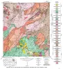
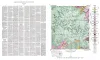
Geologic map of the Palo Alto Creek Quadrangle, Gillespie County, Texas | 1952 | Palo Alto Creek quadrangle is south of the Llano region and is in the marginal portion of the Edwards Plateau where much of the plateau surface has been destroyed by erosion. |
Barnes, V.E. | Geologic Quadrangle Map | Bureau of Economic Geology |
|
Geologic map of the Gold Quadrangle, Gillespie County, Texas | 1952 | Barnes, V.E. | Geologic Quadrangle Map | Bureau of Economic Geology | |
|
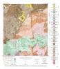
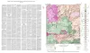
Geologic map of the North Grape Creek Quadrangle, Blanco and Gillespie County, Texas | 1952 | North Grape Creek quadrangle is south of the Llano region and is mostly in the broad Pedernales River basin. A few outliers of the Edwards Plateau are present in the western part of the quadrangle. |
Barnes, V.E. | Geologic Quadrangle Map | Bureau of Economic Geology |
|
Geologic map of the Morris Ranch quadrangle, Gillespie and Kerr Counties, Texas | 1952 | Barnes, V.E. | Geologic Quadrangle Map | Bureau of Economic Geology | |

|
Geologic map of the Bear Creek quadrangle, Gillespie, Kerr, and Kendall Counties, Texas | 1952 | Barnes, V.E. | Geologic Quadrangle Map | Bureau of Economic Geology | |
|
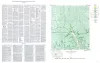
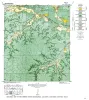
Geologic map of the Cain City quadrangle, Gillespie and Kendall Counties, Texas | 1952 | Cain City quadrangle is south of the Llano region and is in the marginal portion of the Edwards Plateau where much of the plateau surface has been destroyed by erosion. Northeastward-trending lobes and outliers of the Edwards Plateau are present in the southern part. |
Barnes, V.E. | Geologic Quadrangle Map | Bureau of Economic Geology |