|
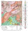
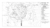
Geologic map of the Willow City quadrangle, Gillespie and Llano Counties, Texas |
1952 |
|
Barnes, V.E. |
Geologic Quadrangle Map |
Bureau of Economic Geology |
|
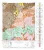
Geologic Map of the Blowout Quadrangle, Blanco, Gillespie, and Llano Counties, Texas |
1952 |
|
Barnes, V.E. |
Geologic Quadrangle Map |
Bureau of Economic Geology |
|
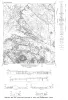
Agua Fria quadrangle, Brewster County, Texas |
1951 |
|
Moon, C.G. |
Miscellaneous Map |
Bureau of Economic Geology |
|
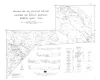
Geologic map and structure sections of the Christmas and Rosillos Mountains, Brewster County, Texas |
1951 |
|
Bloomer, R.R. |
Miscellaneous Map |
Bureau of Economic Geology |
|
Houston County geologic maps |
1944 |
|
Stenzel, H.B., Hurlbut, E.M. |
Miscellaneous Map |
Bureau of Economic Geology |
|
Geologic map of San Saba County, Texas, south of 31 degrees 21minutes latitude |
1940 |
|
Plummer, F.B. |
Miscellaneous Map |
Bureau of Economic Geology |
|
Geologic Map of Leon County, Texas |
1938 |
|
Stenzel, H.B. |
Miscellaneous Map |
Bureau of Economic Geology |
|
Geologic map of Parker County, Texas |
1937 |
|
Armstrong, J.M., Scott, Gayle |
Miscellaneous Map |
Bureau of Economic Geology |

|
Geologic map of Denton County, Texas |
1935 |
|
Winton, W.M., Hawley, J.B. |
Miscellaneous Map |
Bureau of Economic Geology |
|
Geologic map of the Solitario |
1933 |
|
Sellards, E.H., Adkins, W.S., Arick, M.B. |
Miscellaneous Map |
Bureau of Economic Geology |