Geologic Maps Publications
| Title | Publication Year Sort ascending | Abstract | Author | Series | Publisher | |
|---|---|---|---|---|---|---|
|
Geologic map of the Sattler quadrangle, Texas | 1991 | Collins, E.W., Baumgardner, R.W., Jr., Raney, J.A. | Open-File Map | Bureau of Economic Geology | |
|
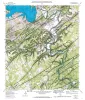
Geologic Atlas of Texas, Wichita Falls-Lawton sheet | 1987 | Geologic map that depicts the surface geology of Hardeman, Wilbarger, Wichita, Clay, Knox, Baylor, Archer, Haskell, Throckmorton, Young, and Foard Counties and part of Jack County, Texas. The 20-page booklet indicates geologic formations, abbreviations, and ages. |
Barnes, V.E., Hentz, T.F., Brown, L.F., Jr., Cleaves, A.W., Kier, R.S., McGowen, J.H., Parrish, W.C., Ramsey, J.W. | Geologic Atlas of Texas | Bureau of Economic Geology |

|
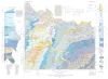
Geologic Atlas of Texas, Dalhart sheet | 1984 | Oversize color geologic map that depicts the surface geology of Dallam County and parts of Sherman, Moore, and Hartley Counties, Texas. The 6-page booklet indicates geologic formations, abbreviations, and ages. |
Barnes, V.E., Eifler, G.K., Fay, R.O., Trauger, F.D., Lappala E.G., Johnson, G.S., Hood, H.C., Stagges, D | Geologic Atlas of Texas | Bureau of Economic Geology |
|
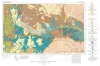
Geologic Atlas of Texas, Tucumcari sheet | 1983 | Geologic map that depicts the surface geology of Oldham County and parts of Hartley, Deaf Smith, Moore, Potter, and Randall Counties. |
Barnes, V.E., Eifler, G.K., Trauger, F.D., Spiegel, Z., Hawley, J.W., Dillon, R.L., Kottlowski, F.E., Hood, C. | Geologic Atlas of Texas | Bureau of Economic Geology |

|
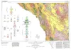
Geologic Atlas of Texas, Fort Stockton sheet (revised 1994) | 1982 | Geologic map that depicts the surface geology of parts of Jeff Davis, Reeves, Pecos, Terrell, Brewster, and Presidio Counties, Texas. The 9-page booklet indicates geologic formations, abbreviations, and ages. |
Barnes, V.E., Humboldt Oil and Refining Co., Mobil Oil Co., Geophoto Services Inc., Cities Service Petroleum Co., Anderson, J.E., Brown, J.B., Gries, J.C. | Geologic Atlas of Texas | Bureau of Economic Geology |

|
Geologic Atlas of Texas, Sonora sheet | 1981 | Geologic map that depicts the surface geology of Sutton County and parts of Terrell, Crockett, Val Verde, Edwards, Kimble, Menard, Schleicher, and Pecos Counties. |
Barnes, V.E., McKalips, D.G., Cities Service Petroleum Co., Geophoto Services Inc., Stump, R.W., Brown, J.B., Pearson, B.T., Volkmann, R.G. | Geologic Atlas of Texas | Bureau of Economic Geology |

|
Geologic Atlas of Texas, Llano sheet | 1981 | Geologic map that depicts the surface geology of Mason, Llano, and Gillespie Counties and parts of Menard, Kimble, San Saba, McCulloch, Edwards, Real, Kerr, Kendall, Blanco, Hays, Travis, Williamson, and Burnet Counties, Texas. |
Barnes, V.E., Shell Oil Co., Boyer, R.E., Clabaugh, S.E., Baker, E.T. | Geologic Atlas of Texas | Bureau of Economic Geology |
| |
Geologic Atlas of Texas, Emory Peak-Presidio sheet | 1979 | Geologic map that depicts the surface geology of parts of Presidio, Brewster, and Terrell Counties, Texas. The 14-page booklet indicates geologic formations, abbreviations, and ages. |
Barnes, V.E., Geophoto Services Inc., Cities Service Petroleum Co., Mobil Oil Co., Cepeda, N.J., Daugherty, F.W., Brown, J.B., Norman, D.B. | Geologic Atlas of Texas | Bureau of Economic Geology |
|
Geologic Atlas of Texas, Marfa sheet | 1979 | Geologic map that depicts surface geology of parts of Hudspeth, Culberson, Jeff Davis, and Presidio Counties, Texas. The 12-page explanatory booklet indicates geologic formations, abbreviations, and ages. |
Barnes, V.E., Twiss, P.C., Continental Oil Co., Cities Service Petroleum Co., Geophoto Services Inc., Norman, D.M., Sherrod, C.H., Pearson, B.T. | Geologic Atlas of Texas | Bureau of Economic Geology |
|
Geologic map of the Round Mountain quadrangle, Blanco, Burnet, and Llano counties. Texas | 1978 | Barnes, V.E. | Geologic Quadrangle Map | Bureau of Economic Geology |