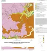
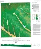
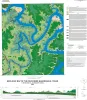
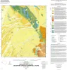
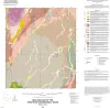
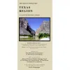
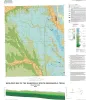
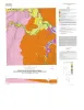
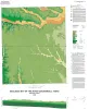
|
Geologic map of the Mission Bay quadrangle: Mission Delta and Copano Bay area, Texas Gulf of Mexico Coast |
2014 |
|
Paine, J.G., Collins, E.W. |
Open-File Map |
Bureau of Economic Geology |
|
Geologic map of the Smithwick quadrangle, Texas |
2014 |
|
Woodruff, C.M., Jr. |
Open-File Map |
Bureau of Economic Geology |
|
Geologic map of the Guadalupe delta, Texas Gulf of Mexico Coast: Sheet 4-Sea Drift quadrangle |
2013 |
|
Collins, E.W., Paine, J.G. |
Open-File Map |
Bureau of Economic Geology |
|
Geologic map of the Guadalupe delta, Texas Gulf of Mexico Coast: Sheet 5-Tivoli quadrangle |
2013 |
|
Collins, E.W., Paine, J.G. |
Open-File Map |
Bureau of Economic Geology |
|
Geologic map of the Poteet quadrangle, Texas |
2013 |
|
Elliott, Brent A. |
Open-File Map |
Bureau of Economic Geology |
|
Geologic map of the Thelma quadrangle, Texas |
2013 |
|
Elliott, Brent A. |
Open-File Map |
Bureau of Economic Geology |
|
Geologic map the Muenster East quadrangle, Texas |
2013 |
|
Collins, E.W. |
Open-File Map |
Bureau of Economic Geology |
|
Geologic map of the Guadalupe delta, Texas Gulf of Mexico Coast: Sheet 1-Austwell quadrangle |
2013 |
|
Paine, J.G., Collins, E.W. |
Open-File Map |
Bureau of Economic Geology |
|
Geologic map of the Guadalupe delta, Texas Gulf of Mexico Coast: Sheet 2-Bloomington SW quadrangle |
2013 |
|
Collins, E.W., Paine, J.G. |
Open-File Map |
Bureau of Economic Geology |
|
Geologic map of the Guadalupe delta, Texas Gulf of Mexico Coast: Sheet 3-Green Lake quadrangle |
2013 |
|
Paine, J.G., Collins, E.W. |
Open-File Map |
Bureau of Economic Geology |