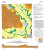
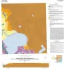
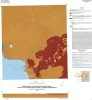
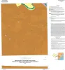
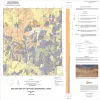
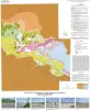
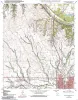
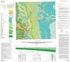
Publications tagged with Geologic Maps
|
Title |
Publication Year
Sort ascending
|
Abstract |
Author |
Series |
Publisher |
|
Geologic map of the Keene quadrangle, Texas |
2010 |
|
Collins, E.W. |
Open-File Map |
Bureau of Economic Geology |
|
Geologic map of the Blum quadrangle, Texas |
2009 |
|
Collins, E.W. |
Open-File Map |
Bureau of Economic Geology |
|
Geologic Map of the Covington quadrangle, Texas |
2009 |
|
Collins, E.W. |
Open-File Map |
Bureau of Economic Geology |
|
Geologic Map of the Files Valley quadrangle, Texas |
2009 |
|
Collins, E.W. |
Open-File Map |
Bureau of Economic Geology |
|
Geologic map of the Itasca quadrangle, Texas |
2009 |
|
Collins, E.W. |
Open-File Map |
Bureau of Economic Geology |
|
Geologic map of the Morgan quadrangle, Texas |
2009 |
|
Collins, E.W. |
Open-File Map |
Bureau of Economic Geology |
|
Geologic map of the Southeast Part of the Austin, Texas, 30x60 Minute Quadrangle; Central Texas Population Corridor Encompassing Bastrop and Smithville |
2008 |
|
Collins, E.W. |
Miscellaneous Map |
Bureau of Economic Geology |
|
Geologic map of the Glenn Spring quadrangle, Big Bend National Park, Texas |
2008 |
|
Collins, E.W., Muehlberger, W.R., Dickerson, P.W. |
Miscellaneous Map |
Bureau of Economic Geology |
|
Geologic map of the Bryan West quadrangle, Texas |
2007 |
|
Collins, E.W. |
Open-File Map |
Bureau of Economic Geology |
|
Geologic map of the Chances Store quadrangle, Texas |
2007 |
|
Collins, E.W. |
Open-File Map |
Bureau of Economic Geology |