
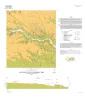
|
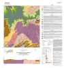
Geologic map of the Turtle Bay quadrangle, Texas Gulf of Mexico coast |
2021 |
|
Paine, J.G., Costard, L. |
Open-File Map |
Bureau of Economic Geology |
|
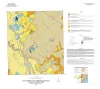
Geologic map of the Grit quadrangle, Mason County, Texas |
2021 |
|
Hunt, B.B., Johnson, B., Helper, M.A. |
Open-File Map |
Bureau of Economic Geology |
|
Geologic map of the Lytton Springs quadrangle, Texas |
2021 |
|
Woodruff, C.M., Jr., Costard, L. |
Open-File Map |
Bureau of Economic Geology |
|
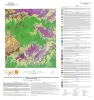
Geologic map of the Pedernales Falls, Johnson City, Howell Mountain, and Round Mountain quadrangles, Blanco County, Texas |
2021 |
|
Hunt, B.B., Woodruff, C.M., Jr., Barnes, V.E. |
Open-File Map |
Bureau of Economic Geology |
|
Geologic map of the Katemcy quadrangle |
2020 |
|
Elliott, Brent A. |
Open-File Map |
Bureau of Economic Geology |
|
Geologic map of the Taylor quadrangle |
2020 |
|
Woodruff, C.M., Jr., Costard, L. |
Open-File Map |
Bureau of Economic Geology |
|
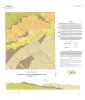
Geologic map of the Bloomington quadrangle, Texas Gulf of Mexico coast |
2020 |
|
Paine, J.G., Costard, L. |
Open-File Map |
Bureau of Economic Geology |
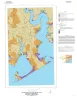
|
Geologic map of the Olivia and part of the Keller Bay quadrangles, Texas Gulf of Mexico coast |
2020 |
|
Paine, J.G., Costard, L. |
Open-File Map |
Bureau of Economic Geology |
|
Geologic map of the Lake Stephenson and part of the Smith Point quadrangles, Texas Gulf of Mexico coast |
2020 |
|
Caudle, T.L., Paine, J.G. |
Open-File Map |
Bureau of Economic Geology |
|
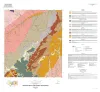
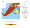
Geologic map of the lower Lake Travis and Lake Austin vicinity, Texas |
2019 |
|
Woodruff, C.M., Jr., Collins, E.W. |
Miscellaneous Map |
Bureau of Economic Geology |