Geologic Maps Publications
| Title | Publication Year Sort ascending | Abstract | Author | Series | Publisher | |
|---|---|---|---|---|---|---|
|
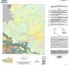
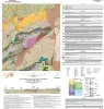
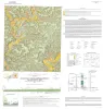
Geologic map of the Diablo Canyon East quadrangle, Hudspeth County, Texas | 2025 | Elliott, Brent A., Short, S.R., Ugurhan, M. | Open-File Map | Bureau of Economic Geology | |
|
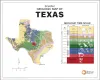
Simplified Geologic Map of Texas with Geologic Time Scale | 2025 | This full-color poster shows a simplified geologic map of Texas created for classroom learning and general interest. The map highlights the major rock types and geologic regions of the state, helping viewers see how Texas was formed over hundreds of millions of years. |
Werner, C.W., Mastrangelo, F.M. | Thematic Maps | Bureau of Economic Geology |
|
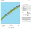
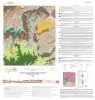
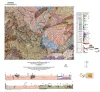
Geologic map of the Decros Point quadrangle, Texas Gulf Of Mexico Coast | 2024 | Aerial imagery used in this study included 0.6- and 1.0-m pixel, natural color, National Agriculture Imagery Program digital imagery photographed in 2020 and 2022. |
Morris, J.N., Paine, J.G. | Open-File Map | Bureau of Economic Geology |
|
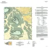
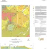
Geologic map of the Norton Mesa quadrangle, Texas | 2024 | Elliott, Brent A. | Open-File Map | Bureau of Economic Geology | |
|
Geologic map of the Loyal Valley quadrangle, Mason County, Texas | 2024 | Hunt, B.B., Helper, M.A., Morris, J.N., Mutis-Duplat, Emilio, Gray, M.W. | Open-File Map | Bureau of Economic Geology | |
|
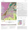
Geologic map of the Montopolis quadrangle, Travis County, Texas | 2023 | This map presents a graphic means for engineers, planners, and property owners to recognize and cope with the changes in substrate properties across this fault zone. Fault displacement has created a profound and abrupt change in land-use capabilities in this area. |
Woodruff, C.M., Jr., Morris, J.N. | Open-File Map | Bureau of Economic Geology |
|
Geologic map of the Panther Creek quadrangle, Mason County, Texas | 2023 | Hunt, B.B. | Open-File Map | Bureau of Economic Geology | |
|
Geologic map of the Monument Mountain SE quadrangle, Mason County, Texas | 2023 | Hunt, B.B. | Open-File Map | Bureau of Economic Geology | |
|
Geologic map of the Dolan Springs quadrangle, Val Verde County, Texas | 2023 | Hunt, B.B., Andrews, J.R., Paine, J.G. | Open-File Map | Bureau of Economic Geology | |
|
Geologic map of a Portion of the Southeastern Llano Uplift, Burnet, Llano, and Blanco Counties Texas | 2023 | Helper, M.A., Hunt, B.B., Barnes, V.E. | Open-File Map | Bureau of Economic Geology |