|
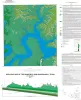
Geologic Map of the Mansfield Dam Quadrangle, Texas |
2017 |
|
Woodruff, C.M., Jr. |
Open-File Map |
Bureau of Economic Geology |
|
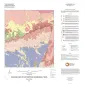
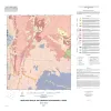
Geologic Map of the Pontotoc Quadrangle, Texas |
2017 |
|
Elliott, Brent A. |
Open-File Map |
Bureau of Economic Geology |

|
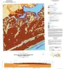
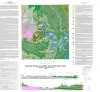
Geologic Map of the Shingle Hills-Dripping Springs-Driftwood-Rough Hollow-Henly-Hammetts Crossing Area, Central Texas |
2017 |
|
Collins, E.W. |
Open-File Map |
Bureau of Economic Geology |
|
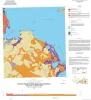
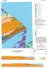
Geologic Map of the Seadrift NE Quadrangle, Texas Gulf of Mexico Coast |
2017 |
|
Paine, J.G., Collins, E.W. |
Open-File Map |
Bureau of Economic Geology |
|
Geologic Map of the Port Lavaca East Quadrangle, Texas Gulf of Mexico Coast |
2017 |
|
Paine, J.G., Collins, E.W. |
Open-File Map |
Bureau of Economic Geology |
|
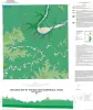
Geologic map of Port O'Connor quadrangle, Texas Gulf of Mexico coast |
2016 |
|
Paine, J.G., Collins, E.W. |
Open-File Map |
Bureau of Economic Geology |
|
Geologic map of the upper Lake Travis area, Texas |
2016 |
|
Woodruff, C.M., Jr., Collins, E.W. |
Miscellaneous Map |
Bureau of Economic Geology |

|
Geologic map of the Saint Charles Bay quadrangle, Texas Gulf of Mexico coast |
2016 |
|
Paine, J.G., Collins, E.W. |
Open-File Map |
Bureau of Economic Geology |
|
Geologic map of the Bee Cave quadrangle, Texas |
2016 |
|
Collins, E.W. |
Open-File Map |
Bureau of Economic Geology |
|
Geologic Map of the Fredonia Quadrangle, Texas |
2016 |
|
Elliott, Brent A. |
Open-File Map |
Bureau of Economic Geology |