Bureau of Economic Geology Publications
| Title | Publication Year Sort ascending | Abstract | Author | Publisher | |
|---|---|---|---|---|---|
|
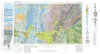
Geologic Atlas of Texas, Abilene sheet | 1972 | Geologic map that depicts the surface geology of Shackelford, Stephens, Palo Pinto, Callahan, and Eastland Counties and parts of Jones, Taylor, Runnels, Coleman, Brown, Comanche, Erath, Parker, and Hood Counties, Texas. |
Barnes, V.E., Brown, L.F., Jr., Goodson, J.L., Southern Minerals Corp., Humble Oil and Refining Co., Shell Oil Co., Harwood, P., Bloomer, R.R. | Bureau of Economic Geology |
|
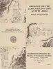
Geology of the Llano region and Austin area: field excursion | 1972 | This Guidebook represents an updating of Bureau of Economic Geology Guidebook No. 5, Field Excursion-Geology of Llano Region and Austin Area. It also represents a modification of Geology of the Llano Region and Austin Area, Texas, published by the Shreveport Geological Society in 1971. |
Barnes, V.E., Bell, W.C., Clabaugh, S.E., Cloud, P.E., Jr., McGehee, R.V., Rodda, P.U., Young, Keith | Bureau of Economic Geology |
|
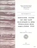
Depositional systems and shelf-slope relationships in upper Pennsylvanian rocks, north-central Texas | 1972 | The Eastern Shelf was a constructional platform developed on the margin of the sediment-starved Midland Basin during Late Pennsylvanian and Early Permian time. A mixed terrigenous-carbonate sedimentary province characterized the shelf during most of its history. |
Galloway, W.E., Brown, L.F., Jr. | Bureau of Economic Geology |
|
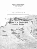
Presidio Bolson, Trans-Pecos Texas and adjacent Mexico: geology of a desert basin aquifer system | 1972 | Mountain-bounded basins or bolsons are the most important aquifer systems throughout most of southwestern and western United States and northern Mexico. |
Groat, C.G. | Bureau of Economic Geology |
|
Environmental geologic Atlas of the Texas coastal zone -- Galveston-Houston area | 1972 | The Texas Coastal Zone is marked by diversity in geography, resources, climate, and industry. |
Fisher, W.L., McGowen, J.H., Brown, L.F., Jr., Groat, C.G. | Bureau of Economic Geology |
|
Fossil vertebrates from the Late Pleistocene Ingleside fauna, San Patricio County, Texas | 1972 | Fresh-water pond deposits at Ingleside, San Patricio County, Texas, have yielded a large Pleistocene vertebrate fauna. The bones are derived from calcareous sands and marls which overlie a marine lagoonal clay. The locality is located just west of the axis of Live Oak Ridge. |
Lundelius, E.L. | Bureau of Economic Geology |
|
The Mineral Industry of Texas in 1970 | 1972 | Zaffarano, R.F., Girard, R.M., Slatick, E.R. | Bureau of Economic Geology | |
|
Mineral deposits in the west Chinati stock, Chinati Mountains, Presidio County, Texas | 1972 | The West Chinati stock, well exposed in San Antonio Canyon and immediately westward on slopes of the southwestern part of the Chinati Mountains, Presidio County, Texas, is a large stocklike body of porphyritic hornblende granite cut by numerous dikes and irregular-shaped plutons of rhyolite, rhyo |
McAnulty, W.N. | Bureau of Economic Geology |
|
Gum Hollow fan delta, Nueces Bay, Texas | 1971 | A study of Gum Hollow delta, a modern fan delta along the north shore of Nueces Bay, Texas, was undertaken to determine the mechanics of fan development and the relationships between sedimentary processes and structures. |
McGowen, J.H. | Bureau of Economic Geology |
|
Sulfur in Texas | 1971 | Ellison Jr., S.P. | Bureau of Economic Geology |