Bureau of Economic Geology Publications
| Title | Publication Year Sort ascending | Abstract | Author | Publisher | |
|---|---|---|---|---|---|
|
Geothermal resources, Frio Formation, South Texas | 1974 | A preliminary study of the Frio sand distribution and formation temperatures and pressures was undertaken in order to define prospective areas in which a more detailed reservoir analysis is necessary prior to the selection of a site for a geothermal well. |
Bebout, D.G., Dorfman, M.H., Agagu, O.K., Granata, G.E., Sanders, G.B. | Bureau of Economic Geology |
|
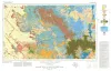
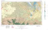
Geologic Atlas of Texas, Big Spring sheet (revised 1994) | 1974 | Geologic map that depicts the surface geology of Borden, Scurry, Fisher, Martin, Howard, Mitchell, and Nolan Counties and parts of Glasscock, Sterling, Coke, Runnels, Taylor, Jones, Dawson, Martin, Lynn, Garza, Kent, and Stonewall Counties. |
Eifler, G.K., Frye, J.C., Leonard, T.F., Barnes, V.E., Trollinger-Gusney and Assoc., Shell Oil Co., Humble Oil and Refining Co., Southern Minerals Corp. | Bureau of Economic Geology |
|
Geologic Atlas of Texas, Brownfield sheet | 1974 | Geologic map that depicts the surface geology of Cochran and Hockley Counties and parts of Bailey, Lamb, Yoakum, Terry, Hale, Lubbock, and Lynn Counties. |
Barnes, V.E., Eifler, G.K., Reeves, C.C., Kottlowski, F.E., Brown, J.B., Briscoe, J.A., DesCamps, J.R., Cities Service Petroleum Co. | Bureau of Economic Geology |
|
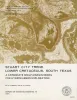
Stuart City trend, Lower Cretaceous, south Texas -- a carbonate shelf-margin model for hydrocarbon exploration | 1974 | Lower Cretaceous shallow-water carbonates accumulated on a broad shelf which completely encircled the Gulf of Mexico. Biogenic growth climaxed along the basinward edge, or shelf margin, where a complex of reefs, banks, bars, and islands developed. |
Bebout, D.G., Loucks, R.G. | Bureau of Economic Geology |
|
Texas lignite: near-surface and deep-basin resources | 1974 | Lignite or low-rank coal is a major energy resource in Texas, providing energy since 1850. Prior to 1930, and the advent of abundant natural gas and oil, lignite was a major energy source. |
Kaiser, W.R. | Bureau of Economic Geology |
|
The Mineral Industry of Texas in 1972 | 1974 | Wood, S.O., Jr., Girard, R.M. | Bureau of Economic Geology | |
|
Depositional systems, San Angelo Formation (Permian), north Texas -- facies control of red-bed copper mineralization | 1974 | The San Angelo Formation is a mid-Permian sandstone and mudstone sequence about 100 feet thick that crops out in North Texas and dips westward into the Midland Basin; it is composed of two superposed members: the basal Duncan Sandstone Member and the overlying Flowerpot Mudstone Member. |
Smith, G.E. | Bureau of Economic Geology |
|
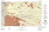
Geologic Atlas of Texas, San Angelo sheet | 1974 | Geologic map that depicts the surface geology of Tom Green, Irion, and Reagan Counties and parts of Midland, Glasscock, Sterling, Coke, Runnels, Concho, Menard, Schleicher, Crockett, and Upton Counties, Texas. |
Barnes, V.E., Eifler, G.K., Shell Oil Co., Southern Minerals Corp., Humble Oil and Refining Co., Cannon, Joe, Brown, W.J., Swartz, G.D. | Bureau of Economic Geology |
|
The Mineral Industry of Texas in 1973 | 1973 | Jirik, C.J., Girard, R.M. | Bureau of Economic Geology | |
|
Asbestos in the Allamoore talc district, Hudspeth and Culberson Counties, Texas | 1973 | The Allamoore district of Hudspeth and Culberson counties, Texas, has become one of the most significant talc-producing areas of the United States. Exploitation of talc deposits in the district began in 1952 with a cumulative production of 120,000 tons through 1957 (Flawn, 1958). |
Rohrbacher, R.G. | Bureau of Economic Geology |