Bureau of Economic Geology Publications
|
Title |
Publication Year
Sort ascending
|
Abstract |
Author |
Publisher |
|
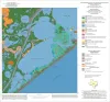
Geoenvironmental map of the Christmas Point quadrangle, Texas |
2004 |
|
Tremblay, T.A., White, W.A., Waldinger, R.L., Collins, E.W. |
Bureau of Economic Geology |
|
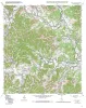
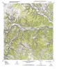
Geologic map of the A Bar A quadrangle, Texas |
2004 |
|
Collins, E.W. |
Bureau of Economic Geology |
|
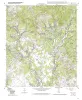
Geologic map of the Bandera Pass quadrangle, Texas |
2004 |
|
Collins, E.W. |
Bureau of Economic Geology |
|
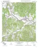
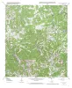
Geologic map of the Center Point quadrangle, Texas |
2004 |
|
Collins, E.W. |
Bureau of Economic Geology |
|
Geologic map of the Echo Hill Ranch quadrangle, Texas |
2004 |
|
Collins, E.W. |
Bureau of Economic Geology |
|
Geologic map of the Fall Creek quadrangle, Texas |
2004 |
|
Collins, E.W. |
Bureau of Economic Geology |
|
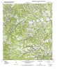
Geologic map of the Hunt quadrangle, Texas |
2004 |
|
Collins, E.W. |
Bureau of Economic Geology |
|
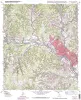
Geologic map of the Kerrville quadrangle, Texas |
2004 |
|
Collins, E.W. |
Bureau of Economic Geology |
|
Geologic map of the Legion quadrangle, Texas |
2004 |
|
Collins, E.W. |
Bureau of Economic Geology |
|
Geologic map of the Love Creek quadrangle, Texas |
2004 |
|
Collins, E.W. |
Bureau of Economic Geology |