|
GeoGulf Transactions Volume 72 (2023) Houston |
|
2023 |
Gulf Coast Association of Geological Societies |
|
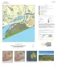
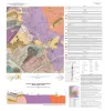
Geologic map of the High Island quadrangle, Texas Gulf of Mexico Coast |
Caudle, T.L., Paine, J.G., Andrews, J.R. |
2022 |
Open-File Map |
|
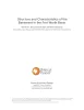
Annual Report of the Bureau of Economic Geology 2022 |
University of Texas at Austin, Bureau of Economic Geology |
2022 |
Annual Reports |
|
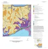
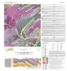
Geologic map of the Palacios NE quadrangle, Texas Gulf of Mexico Coast |
Paine, J.G., Costard, L. |
2022 |
Open-File Map |
|
GCAGS Journal, Volume 11 (2022) |
|
2022 |
Gulf Coast Association of Geological Societies |

|
Geologic map of the Palacios SE quadrangle, Texas Gulf of Mexico Coast |
Paine, J.G., Costard, L., Caudle, T.L. |
2022 |
Open-File Map |

|
Geologic Map of the Bee Cave Quadrangle, Travis County, Texas |
Hunt, B.B., Andrews, J.R. |
2022 |
Open-File Map |
|
Geologic map of the Mason Quadrangle, Mason County, Texas |
Hunt, B.B., Johnson, B., Helper, M.A., Droxler, A. |
2022 |
Open-File Map |
|
Geologic map of the Turtle Creek Quadrangle, Mason County, Texas |
Hunt, B.B., Johnson, B., Helper, M.A., Droxler, A. |
2022 |
Open-File Map |
|
Geologic Map of the Creedmoor Quadrangle, Texas |
Woodruff, C.M., Jr., Costard, L. |
2022 |
Open-File Map |
|
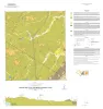
Geologic map of the Mud Lake quadrangle, Texas Gulf of Mexico Coast |
Caudle, T.L., Paine, J.G. |
2022 |
Open-File Map |
|
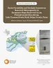
Structure and characteristics of the basement in the Fort Worth Basin |
Horne, E.A., Smye, K.M., Hennings, P.H. |
2022 |
Report of Investigations |
|
Facies variability and geologic controls on reservoir heterogeneity in deepwater slope reservoirs in the Pennsylvanian Cisco Group, Lake Trammel South field, Nolan County, Texas |
Ambrose, W.A., Hentz, T.F., Smith, D.C. |
2022 |
Report of Investigations |
|
Gulf of Mexico Shoreline Change, Eastern Matagorda Peninsula, Texas: Colorado River to Brazos River |
Caudle, T.L., Paine, J.G., Andrews, J.R., Suarez, J.R. |
2021 |
Posters |
|
GCAGS Journal, Volume 10 (2021) |
|
2021 |
Gulf Coast Association of Geological Societies |
|
Gulf of Mexico Shoreline Change, Bolivar Peninsula, Texas: Bolivar Roads to High Island |
Caudle, T.L., Paine, J.G., Andrews, J.R., Suarez, J.R. |
2021 |
Posters |

|
Gulf of Mexico Shoreline Change, Mustang Island and North Padre Island, Texas: Northern Padre Island to Aransas Pass |
Caudle, T.L., Paine, J.G., Andrews, J.R., Suarez, J.R. |
2021 |
Posters |
|
Gulf of Mexico Shoreline Change, Galveston Island, Texas: San Luis Pass to Bolivar Roads |
Caudle, T.L., Paine, J.G., Andrews, J.R., Suarez, J.R. |
2021 |
Posters |
|
Gulf of Mexico Shoreline Change, Brazos River to San Luis Pass, Texas |
Caudle, T.L., Paine, J.G., Andrews, J.R., Suarez, J.R. |
2021 |
Posters |
|
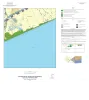
Gulf of Mexico Shoreline Change, High Island to Sabine Pass, Texas |
Caudle, T.L., Paine, J.G., Andrews, J.R., Suarez, J.R. |
2021 |
Posters |