|
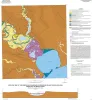
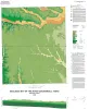
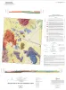
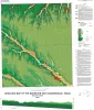
Geologic map of the Mission Bay quadrangle: Mission Delta and Copano Bay area, Texas Gulf of Mexico Coast |
Paine, J.G., Collins, E.W. |
2014 |
Open-File Map |
|
GCAGS Journal, Volume 3 (2014) |
|
2014 |
Gulf Coast Association of Geological Societies |
|
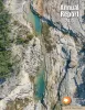
Field Guide to Late Cretaceous Geology...Big Bend |
|
2014 |
Houston Geological Society |
|
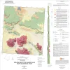
Geologic map of the Smithwick quadrangle, Texas |
Woodruff, C.M., Jr. |
2014 |
Open-File Map |
|
Directory Of Oil Company Name Changes |
Babcock, Paul E. |
2014 |
Houston Geological Society |
|
Sedimentary Basins: Origin, Depositional Histories, and Petroleum Systems |
|
2014 |
Gulf Coast Section SEPM |
|
Tectonostratigraphy and Allochthonous Salt Tectonics of Axel Heiberg Island, Central Sverdrup Basin, Arctic Canada |
Harrison, J.C., Jackson, M.P.A. |
2014 |
Report of Investigations |
|
Aspects of Tertiary Sedimentary Rocks (Paleocene-Miocene), Central Texas Gulf Coast Plain, Revisited |
McBride, E.F., Woodruff, C.M., Jr., Folk, R.L., Hopkins, Janie |
2014 |
Austin Geological Society |
|
Geologic map of the Hood quadrangle |
Collins, E.W. |
2014 |
Open-File Map |
|
Geologic map of the Travis Peak quadrangle |
Woodruff, C.M., Jr. |
2014 |
Open-File Map |
|
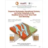
Sequence Stratigraphy, Depositional Systems, and Facies Complexity of the Woodbine Group in East Texas Field: Core Workshop |
Ambrose, W.A., Hentz, T.F., Loucks, R.G., Frébourg, Gregory, Potter, E.C. |
2014 |
Seminars and Workshops |
|
Geologic map of the Gunsight Hills South quadrangle, Texas |
Elliott, Brent A. |
2014 |
Open-File Map |
|
Geologic map of the Lasca quadrangle, Texas |
Elliott, Brent A. |
2014 |
Open-File Map |
|
Annual Report of the Bureau of Economic Geology 2013 |
University of Texas at Austin, Bureau of Economic Geology |
2013 |
Annual Reports |
|
GCAGS Journal, Volume 2 (2013) |
|
2013 |
Gulf Coast Association of Geological Societies |
|
Interdisciplinary Micro to Macroscale Geomechanics |
|
2013 |
Houston Geological Society |
|
Geologic map the Muenster East quadrangle, Texas |
Collins, E.W. |
2013 |
Open-File Map |
|
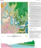
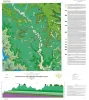
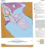
Geologic map of the Guadalupe delta, Texas Gulf of Mexico Coast: Sheet 1-Austwell quadrangle |
Paine, J.G., Collins, E.W. |
2013 |
Open-File Map |
|
Tectonic Map of Texas GIS Data |
Ewing, T.E., Breton, C.L. |
2013 |
GIS Data |
|
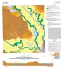
Geologic map of the Guadalupe delta, Texas Gulf of Mexico Coast: Sheet 2-Bloomington SW quadrangle |
Collins, E.W., Paine, J.G. |
2013 |
Open-File Map |