|
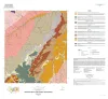
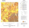
Geologic map of the Katemcy quadrangle |
Elliott, Brent A. |
2020 |
Open-File Map |
|
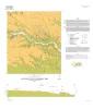
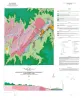
Geologic map of the Taylor quadrangle |
Woodruff, C.M., Jr., Costard, L. |
2020 |
Open-File Map |
|
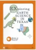
Exploring Earth Science in Texas |
McCall, L.R., Mastrangelo, F.M. |
2020 |
Coloring and Comic Books |
|
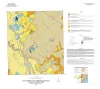
Geologic map of the Bloomington quadrangle, Texas Gulf of Mexico coast |
Paine, J.G., Costard, L. |
2020 |
Open-File Map |
|
Geologic map of the Olivia and part of the Keller Bay quadrangles, Texas Gulf of Mexico coast |
Paine, J.G., Costard, L. |
2020 |
Open-File Map |
|
Anatomy of a Paleozoic Basin: The Permian Basin, USA (vol. 2) |
Ruppel, S.C. |
2020 |
Report of Investigations |
|
GeoGulf Transactions Volume 69 (2019) Houston |
|
2019 |
Gulf Coast Association of Geological Societies |
|
Annual Report of the Bureau of Economic Geology 2019 |
University of Texas at Austin, Bureau of Economic Geology |
2019 |
Annual Reports |
|
GCAGS Journal, Volume 8 (2019) |
|
2019 |
Gulf Coast Association of Geological Societies |
|
Geologic map of the Flake quadrangle, Texas Gulf of Mexico coast |
Caudle, T.L., Paine, J.G. |
2019 |
Open-File Map |
|
Geologic map of the Placedo quadrangle, Texas Gulf of Mexico coast |
Paine, J.G., Costard, L. |
2019 |
Open-File Map |
|
Fifty-Fourth Forum on the Geology of Industrial Minerals |
Elliott, Brent A. |
2019 |
Symposia |
|
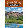
Great Places to View Texas Geology |
Blount, M.W. |
2019 |
Udden Series |
|
Geologic map of the Port Lavaca West quadrangle, Texas Gulf of Mexico coast |
Paine, J.G., Costard, L. |
2019 |
Open-File Map |
|
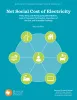
Net Social Cost of Electricity: Policy Smog and Waning Competitive Markets, Lack of Consumer Participation, Importance of the Grid, and Scalability Challenge |
Gulen, Gurcan |
2019 |
Udden Series |
|
Geologic map of the Rossville quadrangle, Texas |
Elliott, Brent A. |
2019 |
Open-File Map |
|
Geologic map of the Leming quadrangle, Texas |
Elliott, Brent A. |
2019 |
Open-File Map |
|
Geologic map of the Pedernales Falls quadrangle, Blanco County, Texas |
Woodruff, C.M., Jr., Costard, L., Barnes, V.E. |
2019 |
Open-File Map |
|
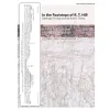
In the Footsteps of R. T. Hill - Geologic Forays around Austin, Texas: A Field Trip in Honor of Edward W. Collins |
Woodruff, C.M., Jr., Paine, J.G., Rose, P.R. |
2019 |
Austin Geological Society |
|
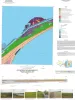
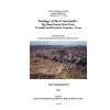
Geology at the Crossroads--Big Bend Ranch State Park, Presidio and Brewster Counties, Texas |
Hall, Blain R., Dickerson, P.W., Hunt, B.B. |
2019 |
Austin Geological Society |