|
GCAGS Journal, Volume 13 (2024) |
|
2024 |
Gulf Coast Association of Geological Societies |
|
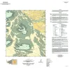
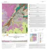
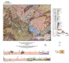
Geologic map of the Norton Mesa quadrangle, Texas |
Elliott, Brent A. |
2024 |
Open-File Map |
|
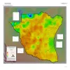
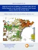
Geothermal Resources, South Texas |
Andrews, J.R. |
2024 |
Open-File Map |
|
GeoGulf Transactions Volume 73 (2024) San Antonio |
|
2024 |
Gulf Coast Association of Geological Societies |
|
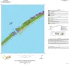
Geologic map of the Decros Point quadrangle, Texas Gulf Of Mexico Coast |
Morris, J.N., Paine, J.G. |
2024 |
Open-File Map |
|
Regional and Local Variability in Lowstand Valley Fill and Deltaic Deposits in the Tannehill Sandstone (Cisco Group), Eastern Shelf of the Permian Basin |
Ambrose, W.A., Hentz, T.F., Rogers, H., Carr, D.L. |
2024 |
Report of Investigations |
|
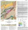
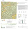
Geologic map of the Loyal Valley quadrangle, Mason County, Texas |
Hunt, B.B., Helper, M.A., Morris, J.N., Mutis-Duplat, Emilio, Gray, M.W. |
2024 |
Open-File Map |
|
Geologic map of the Panther Creek quadrangle, Mason County, Texas |
Hunt, B.B. |
2023 |
Open-File Map |
|
Geologic map of the Monument Mountain SE quadrangle, Mason County, Texas |
Hunt, B.B. |
2023 |
Open-File Map |
|
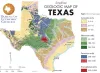
Simplified Geologic Map of Texas Postcard |
Werner, C.W. |
2023 |
Thematic Maps |
|
Evaporitic Sequences Of Texas And New Mexico And Their Relevance For Current Energy Decarbonization |
Martinez-Donate, A., Moscardelli, Lorena, Melani, L., Schuba, Nur, Maraggi, L.R., Ko, Lucy, Bhattacharya, S. |
2023 |
Seminars and Workshops |
|
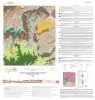
Geologic map of the Dolan Springs quadrangle, Val Verde County, Texas |
Hunt, B.B., Andrews, J.R., Paine, J.G. |
2023 |
Open-File Map |
|
Geologic map of a Portion of the Southeastern Llano Uplift, Burnet, Llano, and Blanco Counties Texas |
Helper, M.A., Hunt, B.B., Barnes, V.E. |
2023 |
Open-File Map |
|
Factors Influencing Rock Strength and Fluid Flow at the Basement–Sediment Interface from Field and Core-Based Observations, Llano Uplift, Texas |
Callahan, O.A., Eichhubl, Peter, Kyle, J.R. |
2023 |
Report of Investigations |
|
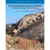
The Geologic Basement of Texas: A Volume in Honor of Peter T. Flawn |
|
2023 |
Report of Investigations |
|
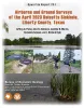
Airborne And Ground Surveys of the April 2023 Daisetta Sinkhole, Liberty County, Texas |
Paine, J.G., Andrews, J.R., Morris, J.N., Saylam, K., Kyle, J.R. |
2023 |
Open-File Report |
|
GeoGulf Transactions Volume 72 (2023) Houston |
|
2023 |
Gulf Coast Association of Geological Societies |
|
Northern Gulf of Mexico Sandstone Reservoir-Quality Database (GOMRQ): Multiple Data Types for Evaluating Reservoir-Quality Risk |
Loucks, R.G., Dutton, S.P. |
2023 |
Report of Investigations |
|
Geologic map of the Montopolis quadrangle, Travis County, Texas |
Woodruff, C.M., Jr., Morris, J.N. |
2023 |
Open-File Map |
|
Annual Report of the Bureau of Economic Geology 2023 |
University of Texas at Austin, Bureau of Economic Geology |
2023 |
Annual Reports |