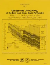
Integrated study of the basin structure, tectonic history, rock physics, physical stratigraphy, hydrogeology, geochemistry, natural resources, and geomorphology of the Palo Duro and Dalhart Basins in the Texas Panhandle is part of a national evaluation of ancient salt basins as potential sites for isolation and management of nuclear wastes.
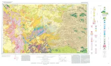
Geologic map that depicts the surface geology of parts of Jeff Davis, Reeves, Pecos, Terrell, Brewster, and Presidio Counties, Texas. The 9-page booklet indicates geologic formations, abbreviations, and ages.
Principal fault systems in the East Texas Basin were examined in terms of their distribution, geometry, displacement history, and possible origins. All the faults studied are normal and moved syndepositionally over approximately 120 Ma (million years); some have listric shapes and associated rollover anticlines. The faults formed by processes associated with gravitationally induced creep of the Louann Salt, such as gliding over a salt decollement zone, crestal extension and collapse over salt pillows and turtle structures, and salt withdrawal from beneath downthrown blocks.