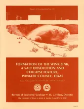
The Wink Sink in Winkler County, Texas, formed on June 3, 1980. Within 24 hours it had expanded to a maximum width of 360 ft (110 m). On June 5, 1980, maximum depth of the sinkhole was 110 ft (34 m), and volume about 5.6 million ft3 (158,600 m3). Between June 3 and June 6, 1980, a large area bordering the south rim of the sink subsided about 10 ft (3 m) relative to the north side. Further subsidence of 1,456 ft (44.4 cm) occurred along the southern rim between July 19 and December 12, 1980.
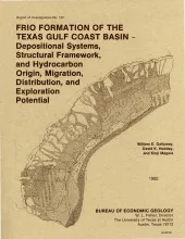
The Frio Formation is one of the major Tertiary progradational wedges of the Texas Gulf Coast Basin and has yielded nearly 6 billion bbl of oil and 60trillion ft30f gas. The Frio and its updip equivalent, the Catahoula Formation, consist of deposits of two large fluvial and associated deltaic systems centered in the Houston and Rio Grande Embayments. Structures in the Houston Embayment are dominated by syndepositional deformation of underlying Jurassic salt.
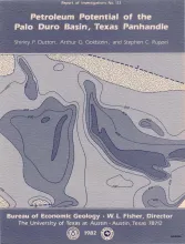
The Palo Duro Basin seemingly has all the elements necessary for hydrocarbon generation and accumulation: reservoirs, traps, source rocks, and sufficient thermal maturity. Porous facies in pre-Pennsylvanian, Pennsylvanian, and Permian strata are potential hydrocarbon reservoirs. Within the pre-Pennsylvanian section, shallow-marine carbonates of both Ordovician (Ellenburger Group) and Mississippian age have sufficient porosity and permeability for hydrocarbon accumulation.
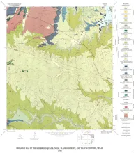
Lineaments perceived in remotely sensed images are reliable indicators of geologic structure. Lineaments on ten Landsat multispectral scanner images (band 5; 1:250,000 scale) were mapped covering the Ouachita/Balcones-Luling-Mexia-Talco structural trend between the Rio Grande and Red river in Texas. More than 5,000 lineaments were perceived in these images. Maps depicting the lineaments (individually and in various combinations) were compared with maps of structural/ tectonic features and geothermal gradient contours, noting instances of apparent correlation among these themes.