Publications by Hendricks, Leo
| Title | Publication Year Sort ascending | Abstract | Author | Series | Publisher | |
|---|---|---|---|---|---|---|
|
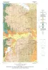
Geology of Midcities Area, Tarrant, Dallas, and Denton Counties, Texas | 1976 | Hendricks, Leo, Sampson, H.H. | Geologic Quadrangle Map | Bureau of Economic Geology | |
|
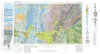
Geologic Atlas of Texas, Abilene sheet | 1972 | Geologic map that depicts the surface geology of Shackelford, Stephens, Palo Pinto, Callahan, and Eastland Counties and parts of Jones, Taylor, Runnels, Coleman, Brown, Comanche, Erath, Parker, and Hood Counties, Texas. |
Barnes, V.E., Brown, L.F., Jr., Goodson, J.L., Southern Minerals Corp., Humble Oil and Refining Co., Shell Oil Co., Harwood, P., Bloomer, R.R. | Geologic Atlas of Texas | Bureau of Economic Geology |
|
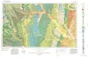
Geologic Atlas of Texas, Dallas sheet (revised 1987) | 1972 | Geologic map that depicts surface geology of Tarrant, Dallas, Kaufman, Ellis, Johnson, Somervell, and Rockwall Counties and parts of Parker, Hood, Erath, Bosque, Hill, Navarro, Henderson, Van Zandt, and Hunt Counties, Texas. |
Barnes, V.E., Shell Oil Co., Humble Oil and Refining Co., Dallas Geological Society, Fort Worth Geological Society, McGowen, J.H., Proctor, C.V., Jr., Haenggi, W.T. | Geologic Atlas of Texas | Bureau of Economic Geology |
|
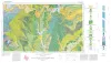
Geologic Atlas of Texas, Sherman sheet (revised 1991) | 1967 | Geologic map that depicts the surface geology of Montague, Cooke, Grayson, Wise, Denton, and Collin Counties and parts of Jack, Fannin, Hunt, and Clay Counties, Texas. The 16-page booklet indicates geologic formations, abbreviations, and ages. |
McGowen, J.H., Hentz, T.F., Owen, D.E., Pieper, M.K., Shelby, C.A., Barnes, V.E., Humble Oil and Refining Co., Pure Oil Co. | Geologic Atlas of Texas | Bureau of Economic Geology |
|
Geology of Parker County, Texas | 1957 | Hendricks, Leo | UT Publication | ||
|
Correlation between surface and subsurface sections of the Ellenberger Group of Texas | 1952 | The Ellenburger of Texas was first defined as a marine limestone formation of Cambrian and Ordovician age (Paige, 1912), but recently it has been subdivided into several formations and the term Ellenburger given group status (Cloud and Barnes, 1948). |
Hendricks, Leo | Report of Investigations | Bureau of Economic Geology |
|
Map of oil, gas, and distillate fields of Texas, December 1945 | 1949 | Hendricks, Leo | Miscellaneous Map | Bureau of Economic Geology | |
|
Mineral Locality Map of Texas | 1944 | Sellards, E.H., Evans, G.L., Hendricks, Leo | Miscellaneous Map | Bureau of Economic Geology |