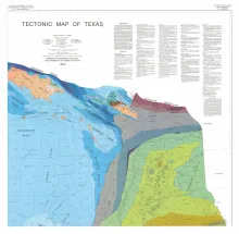
4 oversized sheets, Lambert Conformal Conic projection based on standard parallel 33 degrees and 45 degrees. Accompanied by a text booklet, The Tectonic Framework of Texas.
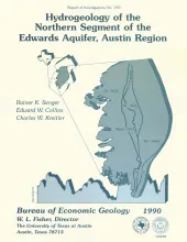
Geologic mapping and fracture analysis of the Lower Cretaceous Edwards aquifer strata near Georgetown and Round Rock, Texas, were performed to provide a better understanding of the geologic framework of the Balcones Fault Zone and to provide information for assessing ground-water flow characteristics. Cretaceous strata dip gently eastward and are locally overlain by terrace deposits and alluvium. Several major normal faults, downthrown to the east, strike northward across the area. Gentle flexures, possibly related to faulting, parallel the faults.
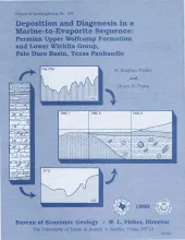
Lower Permian Wolfcamp and Wichita carbonates and anhydrites in the Palo Duro Basin, Texas Panhandle, record a change from normal-marine to marine evaporite depositional environment. These strata also contain a widespread porous and permeable interval that currently comprises a deep-basin brine aquifer system. In this study, we combine lithologic, mineralogic, and petrographic evidence of depositional conditions with the isotopic compositions of carbon, oxygen, sulfur, and strontium to determine the geochemical conditions during deposition and diagenesis.

Petroleum reservoirs typically yield only a fraction of the oil initially in place because geologic heterogeneity causes incomplete drainage of oil. Accurately predicting oil recovery requires realistic estimates of interwell porosity and permeability patterns that are discontinuous in both the horizontal and the vertical direction. Results of this study, which show the effects of heterogeneity on fluid flow and oil recovery efficiency through several simulation experiments, are applicable to many other carbonate and noncarbonate fields worldwide.
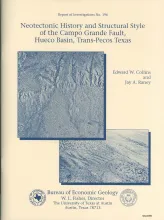
The Hueco Basin of Trans-Pecos Texas and Chihuahua, Mexico, formed in response to Basin and Range extensional tectonism that began about 24 Ma ago and continues to the present. The basin is curvilinear, with the northwestern part of the basin trending north to south and the southeastern part trending northwest to southeast. The Campo Grande fault is located in the southeastern part of the basin. Here the basin is asymmetrical, the thickest sediments having been deposited along the fault-bounded basin axis near the southwestern flank.